
MAY 2001
C
ITY OF PORTLAND
OFFICE OF TRANSPORTATION
ST. JOHNS TRUCK STRATEGY
REPORT AND RECOMMENDATION
C
OLUMBIA
C
ORRIDOR
T
RANSPORTATION
S
TUDY
PORTLAND OFFICE OF TRANSPORTATION
Charlie Hales, Commissioner
Victor F. Rhodes, Director, Office of Transportation
Steve Dotterrer, Program Manager, Planning Division
PROJECT MANAGER
Steve Gerber
PROJECT STAFF
Richard Bellinger, Graphics
Samy Fouts, Graphics
Ken Lindmark, Senior Transportation Planner
Ningsheng Zhou, Transportation Planner
CONSULTANT
Ann Sylvester, Parametrix

OFFICE OF
P
T
ORTLAND
CITY OF
RANSPORTATION
1120 S.W. 5th Avenue, Suite 800
Portland, Oregon 97204
ST. JOHNS TRUCK STRATEGY
REPORT AND RECOMMENDATION
C
OLUMBIA
C
ORRIDOR
T
RANSPORTATION
S
TUDY
JOINT CITIZENS AND TECHNICAL ADVISORY COMMITTEE
Ron Hernandez/Co-Chair/At Large Citizen and North Portland Transportation Committee
Wayne Plaster/Northwest Container Services, Inc.
Donna Babbitt/Friends of Cathedral Park
Scott Batson/Portland Office of Transportation
Leonard Chambers/University Park Neighborhood Association
John Gray/Metro
Brett Kesterson/Portland Office of Transportation
John Lawrence/Green Transfer and Storage
Larry McCord/St. Johns Business Boosters
Jane McFarland/Port of Portland
Larry Olson/Oregon Department of Transportation
Ray Piltz/St. Johns Neighborhood Association
Bill Rabiega/At Large Citizen
Terri Ratliff/At Large Citizen
Doug Walters/T&G Trucking
John Yazzolino/Matlack, Inc.
TABLE OF CONTENTS
EXECUTIVE SUMMARY AND RECOMMENDATION
Introduction . . . . . . . . . . . . . . . . . . . . . . . . . . . . . . . . . . . . . . . . . . . . . . . . . . . . . . . . . . . . . . . . . . . . . . . . . . . . . . . . . . . . 1
Recommendation of the Advisory Committee . . . . . . . . . . . . . . . . . . . . . . . . . . . . . . . . . . . . . . . . . . . . . . . . . . 2
Study Purpose . . . . . . . . . . . . . . . . . . . . . . . . . . . . . . . . . . . . . . . . . . . . . . . . . . . . . . . . . . . . . . . . . . . . . . . . . . . . . . . . . 4
Study Process . . . . . . . . . . . . . . . . . . . . . . . . . . . . . . . . . . . . . . . . . . . . . . . . . . . . . . . . . . . . . . . . . . . . . . . . . . . . . . . . . . 4
Preliminary Evaluation . . . . . . . . . . . . . . . . . . . . . . . . . . . . . . . . . . . . . . . . . . . . . . . . . . . . . . . . . . . . . . . . . . . . . . . . . . 5
General Findings and Conclusions . . . . . . . . . . . . . . . . . . . . . . . . . . . . . . . . . . . . . . . . . . . . . . . . . . . . . . . . . . . . . . 7
Summary of Benefits and Impacts . . . . . . . . . . . . . . . . . . . . . . . . . . . . . . . . . . . . . . . . . . . . . . . . . . . . . . . . . . . . . . . . . 11
CHAPTER ONE: INTRODUCTION
Why Study the Columbia Corridor and the North Portland Peninsula . . . . . . . . . . . . . . . . . . . . . . . . . 15
CHAPTER TWO: EXISTING CONDITIONS
Area Character . . . . . . . . . . . . . . . . . . . . . . . . . . . . . . . . . . . . . . . . . . . . . . . . . . . . . . . . . . . . . . . . . . . . . . . . . . . . . . . . . 17
Land Use . . . . . . . . . . . . . . . . . . . . . . . . . . . . . . . . . . . . . . . . . . . . . . . . . . . . . . . . . . . . . . . . . . . . . . . . . . . . . . . . . . . . . . . 17
Transportation Network Characteristics . . . . . . . . . . . . . . . . . . . . . . . . . . . . . . . . . . . . . . . . . . . . . . . . . . . 19
Truck Characteristics . . . . . . . . . . . . . . . . . . . . . . . . . . . . . . . . . . . . . . . . . . . . . . . . . . . . . . . . . . . . . . . . . . . . . . . 21
CHAPTER THREE: ALTERNATIVES
Long Range Alternatives . . . . . . . . . . . . . . . . . . . . . . . . . . . . . . . . . . . . . . . . . . . . . . . . . . . . . . . . . . . . . . . . . . . . . . . . 23
Short-Term Alternatives . . . . . . . . . . . . . . . . . . . . . . . . . . . . . . . . . . . . . . . . . . . . . . . . . . . . . . . . . . . . . . . . . . . . . . . . 25
CHAPTER FOUR: RECOMMENDATIONS
Transportation Improvement Program . . . . . . . . . . . . . . . . . . . . . . . . . . . . . . . . . . . . . . . . . . . . . . . . . . . . . . . . . . . . . 31
Administrative Recommendations . . . . . . . . . . . . . . . . . . . . . . . . . . . . . . . . . . . . . . . . . . . . . . . . . . . . . . . . . . . . . . 36
CHAPTER FIVE: CITIZEN INVOLVEMENT
Summary . . . . . . . . . . . . . . . . . . . . . . . . . . . . . . . . . . . . . . . . . . . . . . . . . . . . . . . . . . . . . . . . . . . . . . . . . . . . . . . . . . . . . . . 43
Background/City Council Mandate . . . . . . . . . . . . . . . . . . . . . . . . . . . . . . . . . . . . . . . . . . . . . . . . . . . . . . . . . . . . . . 44
Advisory Committee . . . . . . . . . . . . . . . . . . . . . . . . . . . . . . . . . . . . . . . . . . . . . . . . . . . . . . . . . . . . . . . . . . . . . . . . . . . 44
Open Houses/Information Fair . . . . . . . . . . . . . . . . . . . . . . . . . . . . . . . . . . . . . . . . . . . . . . . . . . . . . . . . . . . . . . . . . 45
Notification . . . . . . . . . . . . . . . . . . . . . . . . . . . . . . . . . . . . . . . . . . . . . . . . . . . . . . . . . . . . . . . . . . . . . . . . . . . . . . . . . . . . . 46
Neighborhood and Interested Parties, Outreach . . . . . . . . . . . . . . . . . . . . . . . . . . . . . . . . . . . . . . . . . . . . . . . . 47
Coordination with Affected Jurisdictions . . . . . . . . . . . . . . . . . . . . . . . . . . . . . . . . . . . . . . . . . . . . . . . . . . . . . . . . . . 47
CHAPTER SIX: POLICY ASSESSMENT
City Transportation Goals and Policies . . . . . . . . . . . . . . . . . . . . . . . . . . . . . . . . . . . . . . . . . . . . . . . . . . . . . . . . . . . . 49
Other Applicable City Goals and Policies . . . . . . . . . . . . . . . . . . . . . . . . . . . . . . . . . . . . . . . . . . . . . . . . . . . . . . . 56
Regional (Metro) Transportation Plan Requirements . . . . . . . . . . . . . . . . . . . . . . . . . . . . . . . . . . . . . . . . . . . . 57
Oregon Revised Statutes, Transportation Planning Rule . . . . . . . . . . . . . . . . . . . . . . . . . . . . . . . . . . . . . . . . . . . 61
1. Recommended Projects Map . . . . . . . . . . . . . . . . . . . . . . . . . . . . . . . . . . . . . . . . . . . . . . . . . . . . . . . . . . . . . . . . . . . . 14
2. Study Area . . . . . . . . . . . . . . . . . . . . . . . . . . . . . . . . . . . . . . . . . . . . . . . . . . . . . . . . . . . . . . . . . . . . . . . . . . . . . . . . . . . . . 15
3. Area Character and Land Use . . . . . . . . . . . . . . . . . . . . . . . . . . . . . . . . . . . . . . . . . . . . . . . . . . . . . . . . . . . . . . . . . . 18
4. Transportation Network Characteristics . . . . . . . . . . . . . . . . . . . . . . . . . . . . . . . . . . . . . . . . . . . . . . . . . . . . . . . . . . 20
5. Long Range Options . . . . . . . . . . . . . . . . . . . . . . . . . . . . . . . . . . . . . . . . . . . . . . . . . . . . . . . . . . . . . . . . . . . . . . . . . . . . 24
6. Universe of Alternatives . . . . . . . . . . . . . . . . . . . . . . . . . . . . . . . . . . . . . . . . . . . . . . . . . . . . . . . . . . . . . . . . . . . . . . . . 29
7. TC/S No. 1 (Traffic Calming/Safety) . . . . . . . . . . . . . . . . . . . . . . . . . . . . . . . . . . . . . . . . . . . . . . . . . . . . . . . . . . . . . 32
8. TC/S No. 2 . . . . . . . . . . . . . . . . . . . . . . . . . . . . . . . . . . . . . . . . . . . . . . . . . . . . . . . . . . . . . . . . . . . . . . . . . . . . . . . . . . . . . 32
9. TC/S No. 3 . . . . . . . . . . . . . . . . . . . . . . . . . . . . . . . . . . . . . . . . . . . . . . . . . . . . . . . . . . . . . . . . . . . . . . . . . . . . . . . . . . . . . 32
10. TC/S No. 4 . . . . . . . . . . . . . . . . . . . . . . . . . . . . . . . . . . . . . . . . . . . . . . . . . . . . . . . . . . . . . . . . . . . . . . . . . . . . . . . . . . . . . 33
11. TSI No. 1 (Truck Street Improvement) . . . . . . . . . . . . . . . . . . . . . . . . . . . . . . . . . . . . . . . . . . . . . . . . . . . . . . . . . . 34
12. TSI No. 2 . . . . . . . . . . . . . . . . . . . . . . . . . . . . . . . . . . . . . . . . . . . . . . . . . . . . . . . . . . . . . . . . . . . . . . . . . . . . . . . . . . . . . . . 34
13. TSI No. 3 . . . . . . . . . . . . . . . . . . . . . . . . . . . . . . . . . . . . . . . . . . . . . . . . . . . . . . . . . . . . . . . . . . . . . . . . . . . . . . . . . . . . . . . 35
14. TSI No. 4 . . . . . . . . . . . . . . . . . . . . . . . . . . . . . . . . . . . . . . . . . . . . . . . . . . . . . . . . . . . . . . . . . . . . . . . . . . . . . . . . . . . . . . . 35
15. Designated Truck Streets . . . . . . . . . . . . . . . . . . . . . . . . . . . . . . . . . . . . . . . . . . . . . . . . . . . . . . . . . . . . . . . . . . . . . . . . . . 42
16. Reroute of US 30 Bypass . . . . . . . . . . . . . . . . . . . . . . . . . . . . . . . . . . . . . . . . . . . . . . . . . . . . . . . . . . . . . . . . . . . . . . . . . 55
17. Truck Route Segment Improvements . . . . . . . . . . . . . . . . . . . . . . . . . . . . . . . . . . . . . . . . . . . . . . . . . . . . . . . . . . . . . . 60
LIST OF TABLES
1. Cost Estimates, Traffic Calming/Safety . . . . . . . . . . . . . . . . . . . . . . . . . . . . . . . . . . . . . . . . . . . . . . . . . . . . . . . . . . . 33
2. Cost Estimates, Truck Street Improvements . . . . . . . . . . . . . . . . . . . . . . . . . . . . . . . . . . . . . . . . . . . . . . . . . . . . . . 36
3. The Gross Vehicle Weight of Some Potentially Affected Vehicles,
for Comparison Purposes Only . . . . . . . . . . . . . . . . . . . . . . . . . . . . . . . . . . . . . . . . . . . . . . . . . . . . . . . . . . . . . . . . . . 37
LIST OF FIGURES

EXECUTIVE SUMMARY & RECOMMENDATION
St. Johns Truck Strategy 1
INTRODUCTION
This Executive Summary contains a summary of the study purpose, process and findings from the
St. Johns Truck Strategy (SJTS) and the recommendation of the SJTS Advisory Committee (AC)
appointed to help direct the study. The Executive Summary includes the Recommendation of the Advisory
Committee, presented first, followed by sections on Study Purpose, Study Process, Preliminary Evaluation,
General Findings and Conclusions, and Summary of Benefits and Impacts. A brief description of the content
of each of these sections follows.
The Recommendation of the Advisory Committee relates the AC’s majority conclusions and their
recommendation to the City Council. The representatives of the St. Johns Neighborhood Association
and the Friends of Cathedral Park have stated that they will prepare a minority report, which will be
forwarded to the City Council under separate cover.
The Study Purpose describes the background, intent and objectives of the study as derived from previous
actions (Columbia Corridor Transportation Study), City Council mandate and the AC. Maps of the
originally identified issues and potential solution are attached.
The Study Process section provides a general description of the manner in which the study and the AC
was composed, managed and conducted, including the selection of alternatives.
The Preliminary Evaluation includes a list of the original 47 project, program, and policy alternatives
compiled by the AC, and the evolution of those alternatives to the list of final alternatives.
The General Findings and Conclusions relates the AC’s fundamental findings and assessment of the final
alternatives, including a brief description of each of the final project alternatives, and the policy, study, and
program alternatives.
The Summary of Benefits and Impacts identifies the positive and negative features of the final
recommendation selected by the AC. A list of technical memoranda and other documents prepared for
this study provide a background for the AC’s deliberations.
A map of the final transportation improvements developed by the AC is attached. The program, policy
and project alternatives were derived from the application of various screening and evaluation criteria to
the original alternatives, as described in the Study Process section of the Executive Summary.

EXECUTIVE SUMMARY & RECOMMENDATION
St. Johns Truck Strategy2
RECOMMENDATION OF THE ADVISORY COMMITTEE
The charge of the AC was two-fold:
1. Identify ways in which truck circulation can be improved between the St. Johns Bridge, Rivergate
and I-5
2. Determine how non-local truck traffic can be eliminated or reduced on residential and retail
commercial streets
The parameters of this charge, as established by the City Council, includes:
1. Utilize the existing local and regional street system;
2. Be a short-term (2-5 year) solution;
3. Not include more than $10 million in solutions;
4. Coordinate with other North Portland projects; and
5. Carefully analyze solutions so as to not shift a problem to a different location
The AC has identified the above charge as appropriate to an interim or short-term improvement or
action only. A solution to the problem will need to eliminate through truck movements from the St.
Johns retail core and Pedestrian District. This action was identified as paramount to the livability,
economics and safety of the area. However, the majority of the AC has recognized that elimination of
trucks from the St. Johns retail core area falls outside the scope of this study. In recognition of the
importance of a long-range solution, a recommendation for removing the trucks from the St. Johns core
area has been forwarded to Metro. This recommendation encourages and promotes the acceleration
and prioritization of a listed Regional Transportation Plan feasibility study for a new bridge crossing the
Willamette River from the north Portland peninsula to US 30 and the northwest industrial districts.
In terms of short-term improvements, the majority of the AC has recommended a combination of
actions falling into two categories, transportation improvements and administrative actions, which
includes two regulatory actions, three operational directives, and one policy.
Transportation Improvements
The first category, transportation improvements, is broken down into two types of improvement. The
first provides for mitigation of truck impacts, neighborhood livability and safety for pedestrians and
bicyclists. However, the safety and livability improvements would not, by themselves, reduce the area of
impacts from non-local trucks.
The second category of transportation improvement provides for improvements on the recommended
truck streets to increase the efficiency of truck movement and to encourage non-local trucks to stay on
the designated route. However, the truck improvements by themselves would result in a greater number
of truck trips on the designated truck streets.
1. Provide traffic calming to enhance pedestrian and bicycle safety for Lombard Street (Pier Park to St.
Louis), Fessenden (Columbia Way to St. Louis), and St. Louis (Fessenden to Lombard), pedestrian and
bicycle safety on Columbia Boulevard, and to create a street environment that helps to protect the
neighborhood streets from incursion by non-local truck traffic; and
2. Redesign and reconstruct the intersections of Lombard/St. Louis/Ivanhoe, Ivanhoe/Philadelphia, and

EXECUTIVE SUMMARY & RECOMMENDATION
St. Johns Truck Strategy 3
Columbia Boulevard/Portland/Columbia Way, and the street segment of Burgard and Lombard from
Rivergate entrance to Terminal Road, to provide for both improved truck movement, and pedestrian
and bicycle safety.
Administrative Recommendations
With Council adoption, the Portland Office of Transportation would be directed to consider:
• Two regulatory recommendations, which would require further study and staff action to assess the
appropriate manner of implementation
• Three operational directives
• One policy
Of the regulatory actions recommended, one would assess the feasibility of limiting local deliveries to
vehicles with no more than 18,000 lbs. gross vehicle weight (GVW). The second regulation
recommended is for review and analysis of the present practices for the movement of hazardous
materials, potentially affecting routing and delivery.
1. Assess the feasibility of limiting the gross vehicle weight (GVW), for all local deliveries, to 18,000 lbs.
2. Analyze the type and quantity of materials and materials routing presently allowed for hazardous
materials, and make recommendations for any necessary changes to enhance protection for people,
neighborhoods and natural resources.
Three recommendations are made affecting the operational or organizational aspects of the Portland
Office of Transportation. A study is recommended that would be a follow-up study or continuation of
the SJTS, to ascertain the effectiveness of implemented recommendations. The second operational
recommendation would create a program for education about and enforcement of truck regulations,
including providing a “point-of-contact” for both industry and citizens. The third recommendation would
establish a program to inventory, review, design, place and maintain signs for truck traffic.
1. The St. Johns Truck Strategy Advisory Committee will be continued, to investigate the success of
adopted/implemented short-term projects, and to recommend remedial or alternative actions if
necessary.
2. A program promoting education and enforcement will be initiated to provide interested and effected
parties with a point of contact, information services and enforcement of truck regulations.
3. A citywide (truck) sign program will be initiated, for the design and placement of new signs and
maintenance of existing signs.

EXECUTIVE SUMMARY & RECOMMENDATION
St. Johns Truck Strategy4
One policy recommendation is made, effecting the existing Transportation Element and the
Transportation Element as proposed for amendment by the Transportation System Plan. This policy
would be implemented by adding the Major Truck Street designation to the identified street segments on
the city-wide and/or North Transportation District Truck Route Maps. The following policy is
recommended for inclusion in the Transportation System Plan:
1. Designate the segments of Lombard Street, St. Louis Avenue and Ivanhoe Street, between Burgard
Road and Philadelphia Avenue, as Major Truck Streets in the North Transportation District of the
Transportation Element.
STUDY PURPOSE
As a part of the 1992 update of the Transportation Element of the Comprehensive Plan, the North
Portland Peninsula neighborhoods requested, and the City Council mandated, that the Portland Office of
Transportation look at ways to reduce the amount of truck traffic traveling on neighborhood streets. At
the same time, a need was identified for transportation system improvements for truck travel to
commercial or industrial sites, the freeway system, and the St. John’s Bridge.
The primary goal of the study is to eliminate or reduce conflicts between non-local truck movement and
the residential and retail-commercial areas in St. Johns. The alternatives reviewed range from high-cost,
regional issues such as construction of a new bridge, to low-cost and/or low-impact solutions such as
signs. The Mission Statement bests sums up the purpose of this study:
“Evaluate and recommend to City Council appropriate transportation solutions that address freight
movement needs of the North Portland industrial areas and protect the St. John’s residential and
commercial hub from through-truck infiltration. The recommended solutions will recognize the
contribution of freight movement to the local, regional and state economies, and that a significant
portion of that freight is moved to and from the industrial areas of North, Northeast and Northwest
Portland.”
STUDY PROCESS
The need to combine information and knowledge of infrastructure, neighborhood and trucking issues
drove the selection of a combined technical and citizen advisory committee. The 17 member AC was
composed of six citizen volunteers, including business representation, five representatives from truck-
related businesses, three City of Portland employees, and representatives from ODOT, Metro and the
Port of Portland. Co-Chairs provided the AC’s leadership, one from the neighborhood side and one
from the trucking side.
The St. Johns and University Park Neighborhood Associations, Friends of Cathedral Park, and the St.
Johns Business Boosters were represented on the AC, while the Linnton Neighborhood Association and
the Community Association of Portsmouth chose not to participate directly, but remained informed
through receipt of agenda and minutes.

EXECUTIVE SUMMARY & RECOMMENDATION
St. Johns Truck Strategy 5
The SJTS AC conducted business through fifteen meetings held between April 19, 1999 and June 26,
2000, not including two Open Houses and the May 5, 2000 Columbia Corridor Information Fair. The
two Open House events occurred on March 15, 1999 and May 6, 2000. All AC meetings, including three
subcommittee meetings, were open to the public for observation and comment. The second Open
House successfully elicited over 100 written comments. At least one progress report was delivered by
staff to all identified neighborhood associations, and to North Portland Neighborhood Services.
In addition to the expertise brought to the AC by the agency representatives, the Port of Portland hired
an engineering and environmental consulting firm (Parametrix, Inc.) to provide additional technical
expertise for analysis of traffic impacts. The City Council and Port of Portland Board approved the
consultant selection and work program. Other experts were also solicited to provide information or
appear before the group. These other experts addressed relevant area projects and topics, including the
St. Johns Bridge rehabilitation, hazardous materials, truck-related pollution, traffic calming, Federal Highway
System regulation and rules, project cost, police enforcement, traffic modeling, commodity flow and truck
mobility and access needs, and port operations.
The study process began with assumptions and concerns identified in 1991, during the review and
update of the Transportation Element of the Comprehensive Plan. Both the first Open House and
subsequent AC meetings added to the list of existing concerns and issues. Information on truck
movement (2020 traffic modeling information, commodity flow patterns, and existing truck counts) was
provided to the AC, including assumed growth patterns and Regional Transportation Plan assumptions
about improvements to the regional and local street systems.
The AC reviewed an original list of 47 concept alternatives including several that were beyond the scope
of this study. The AC proposed and adopted criteria by which to weigh the alternatives (See: Appendix B),
and which were intended to assure that the alternatives met various study framework requirements and
also provided a basic assessment of general performance, technical and implementation characteristics.
Alternatives were selected for the short list that are intended to both enhance truck movement on the
designated route and to protect bicycle and pedestrian safety and neighborhood livability. The final
alternatives (See: Recommendation of the Advisory Committee, above.) form a package of actions to be
taken in various locations, on various streets or at various intersections. The entire package of
recommended actions is estimated to have a cost of $6.7 Million, less than the $10 Million identified as a
target by the City Council.
PRELIMINARY EVALUATION
The preliminary evaluation of 47 original alternatives (below) resulted in selection of nine specific
projects, each with an emphasis on the improvement of bicycle and pedestrian safety. The AC presented
these projects and the selected policies, programs and studies for public review and comment prior to
their final deliberations. The preliminary evaluation by the AC resulted in projects, policies, programs and
studies that worked together to achieve the desired objectives of this study. The expected outcome of
the public review was either refinement or exclusion of the presented projects, and/or the way they
were packaged.

EXECUTIVE SUMMARY & RECOMMENDATION
St. Johns Truck Strategy6
1. The truck route accessing the St. Johns Bridge should
be located on Lombard/St. Louis/Ivanhoe. (Policy
consideration)
2. The truck route accessing the St. Johns Bridge should
be located on Columbia Way/Fessenden. (Policy
consideration)
3. Remove Ivanhoe from existing truck route; allow
trucks to access Philadelphia Street/St. Johns Bridge via
Lombard. (Policy Consideration: A.3. Option H, pg 11,
Problem Statement and Solution Proposal)
4. The truck route accessing the St. Johns Bridge should
be located on Lombard, east of St. Johns. (Policy
consideration)
5. Identify a second (alternative) route for moving trucks
across the peninsula: Fessenden, Smith, Lombard, and
other alternatives. (Policy Consideration)
6. Limit local deliveries to trucks weighing 18,000 lbs. or
less; prohibit heavier trucks except on designated
route(s). (Policy consideration)
7. Request change of US 30 Bypass designation from
Lombard, east of St. John’s, to the recommended truck
route. See 1 - 3, above. (Request through region to
National Highway Administration)
8. Re-align Lombard between St. Johns and St. Louis,
shifting roadway north and east of existing roadway,
removing fronting residential structures, and install a
sound wall to protect remaining residential properties.
($6.38m +/- 40%)
9. Implement signing on I-5 to encourage/require the use
of I-5 for access to US 30 or other west side
destinations, and/or to direct trucks to Columbia Blvd.
(Regional Issue: request to ODOT)
10. Create a full freeway interchange at N. Columbia
Boulevard and I-5. (In Regional Transportation Plan,
$70m +/-)
11. Mandate and fund follow-up, including continuation for
review by the existing committee, to determine the
efficacy of short-term projects. (Study)
12. Consider use of T-2 as a support facility for T-4, T-6,
Rivergate (or other terminals or facilities), barging
deliveries, goods, etc. to these places, eliminating some
quantity of trucks. (See: Letter from Port Marine Division,
Scott Van Wormer)
13. Add ramp from eastbound Columbia Blvd. to
northbound Portland Rd. and prioritize the movement
between Portland Rd. and Columbia Blvd. (A.1., Option
A, pg 2, PSSP)
14. Adjust signal timing: lengthen green time on designated
truck routes, shorten signal cycles on non-truck streets,
eliminate signals where possible on truck routes. (A.1.,
Option B, pg 3, PSSP)
15. Install signing at N Portland/N Columbia intersection,
directing trucks to Columbia. (A.1., Option C, pg, 3, PSSP)
16. Designate area truck routes and install directional
signing. (A.1., Option C, pg 3 and Option G, pg 4, PSSP:
limited sign program)
17. Initiate a truck signing program city-wide to provide
identification/direction of appropriate routes (i.e.,
where are the truck routes) and discourage non-local
truck movement where inappropriate. (A.1., Option C,
pg 3 and Option G, pg 4, PSSP: city-wide sign program)
18. Add traffic capacity on I-205 through use of
permanent HOV lanes. (A.1., Option D, pg 3, PSSP)
19. Add slip lane from southbound Denver to westbound
Argyle Way (A.1., Option E, pg 3, PSSP)
20. Reconfigure I-5 from 3 travel lanes in each direction to
2 travel lanes in each direction with 2 center reversible
lanes. (A.1., Option F, pg 3, PSSP)
21. Redesign/rebuild intersection of Ivanhoe/Lombard/St.
Louis to better accommodate the movement of trucks
from Lombard to Ivanhoe, but restrict truck
movement from St. Louis to Ivanhoe. (A.1., Option H,
pg 4, PSSP)
22. Same as above, but remove no housing. (A.1., Option
H, pg 4, PSSP)
23. Realign the Philadelphia/Ivanhoe intersection to favor
movement between the St. Johns Bridge and Ivanhoe.
(A.1., Option I, pg 5, PSSP)
24. Remove or replace pedestrian overcrossing on
Columbia Blvd. at Midway. (A.1., Option J, pg 6, PSSP)
25. Replace bridge over the UPRR tracks at Lombard, east
of T-4. (A.1., Option K, pg 6, PSSP)
26. Redesign N Burgard between Columbia Blvd. and
Terminal 4 to better accommodate trucks. (A.1.,
Option L, pg 7, PSSP)
27. Remove the signal at Argyle St./Interstate Pl. to
facilitate movement on Columbia. (A.1., Option M, pg 7,
PSSP)
28. Provide an updated study of a T-4 access road, to
identify access to the St. Johns Bridge with minimum
impact to residential streets. (A.2., Option E, pg 8, PSSP)
29. Reduce or eliminate left turn movements to and from
Columbia Blvd., or design turn pockets to limit long
vehicle access. (A.3., Option A, pg 8, PSSP)
30. Add curb extensions, median islands, traffic circles, or
roundabouts at intersections to limit access of long
vehicles. (A.3., Option B, pg 8, PSSP)
31. Place restrictions on large trucks at Portland Road,
Columbia, Portsmouth intersections to direct trucks to
Columbia Boulevard for east-west movement. (A.3.,
Option B, pg 8 and C.1., A, pg 14, PSSP)
32. Add 22-foot (split) speed bumps on Neighborhood
Collector Streets: Columbia Way, Fessenden, St. Louis.
Modifies travel time, especially for longer and heavier
vehicles. (A.3., Option C, pg 9, PSSP)
Policy, Program, Study and Project -Alternatives:

EXECUTIVE SUMMARY & RECOMMENDATION
St. Johns Truck Strategy 7
As might be expected, there were and continue to be concerns regarding improvements for truck
movement. The most important concern is that an improved route for trucks will attract even more
truck trips then before. However, the majority of the AC has recognized that trucks cannot be expected
to adhere to a limitation of one truck route, if that route is insufficient to adequately handle all the
expected truck traffic, especially when there is now no restriction on the choice of streets for truck
movement.
GENERAL FINDINGS AND CONCLUSIONS
Information has been provided to the AC to assist them in the preparation and selection of final
recommendations, by compiling – as clearly as possible – the most relevant and fundamental findings and
conclusions to the comparison of alternatives and the decision-making process.
• Since 1992 there has been no designated truck street(s) between Rivergate and Columbia Boulevard
and the St. Johns Bridge. Truck movement through this area is unrestricted.
• Only with the designation of a non-local or “through” truck route can other streets have limitations
to truck movement applied to them.
• The St. Johns Bridge is part of the Federal Highway System (US 30 Bypass) and within one mile of a
designated National Network Highway (US 30). Any limitation to truck movement on the St. Johns
Bridge must be based on safety; and ODOT engineers have found that the bridge has adequate
structural integrity and design to accommodate trucks.
• Many of the non-local trucks traveling between I-5 and US 30 are now regularly using Fessenden
Street and other residential and retail-commercial streets as de facto truck streets. As presently
configured Fessenden is a broad and barrier free street with easy access from Portland Road and St.
Louis Avenue.
33. Add 22-foot speed bumps on non-emergency streets:
Fessenden, Columbia Way, Oswego, Columbia Blvd.,
Smith. (A.3., Option C, pg 9, of SJTS, PSSP)
34. Change the design of Fessenden to discourage non-
local trucks. (A.3., Options C-F, ppg 9 and 10, PSSP)
35. Reduce posted speed limits on Neighborhood
Collector Streets: Fessenden and St. Louis. (A.3.,
Option D, pg 9, PSSP: request to ODOT)
36. Eliminate the right-turn only lane on westbound
Columbia Way to northbound Fessenden. (A.3., Option
E, pg 10, PSSP)
37. Change the appearance and function of certain streets
by reducing the number of through lanes by adding left
turn lanes, bike lanes and parking: Fessenden, St. Louis,
Columbia Way, Macrum. (A.3.,Option F, pg 11, PSSP)
38. Change the allocation of roadway space on
Philadelphia and the St. Johns Bridge to: two vehicle
lanes and two bike lanes. (A.3., Option G, pg 11, PSSP)
39. Modify the existing truck route to have trucks turn off
of Lombard to Ivanhoe at St. Johns, rather than St.
Louis. (Policy consderation: A.3. Option I, pg 11, PSSP)
40. Enforce truck regulations, in concert with education of
the trucking community. (A.3. Option J, pg 11, PSSP)
41. When the St. Johns Bridge is closed for repairs, the
choice of detour routes should be analyzed for the
possibility of designation of a permanent route or
routes for trucks, not including the St. Johns Bridge.
(A.3. Option K, pg 11, PSSP)
42. Redesign of N Portland/Marine Drive intersection to
discourage use of N Portland Road. (A.3. Option L, pg
11, PSSP)
43. Survey Local Service Streets to alter the ability to
speed for all vehicles, through use of 14-foot speed
bumps. Some streets have already been evaluated for
this option. (B.1., Option A, pg 12, PSSP)
44. Improve safety for pedestrians and bicylists at street
crossings, through the use of medians, curb extensions,
marked crosswalks, bike lanes, and landscaping.
Intersections to consider have been identified. (C.1.,
Option A, pg 14, PSSP)
45. Include pedestrian/bicycle safety elements in any
recommendation increasing truck movement along any
of the above routes. (C.1., Option A and C, pg 14, PSSP)
46. Review current Tri-Met bus routes and locations of
current bus stops, for safety and influence on the flow
of traffic. (C.1., Option B, pg 14, PSSP)
47. Install bike lanes where possible on designated bike
routes. (C.1., Option C, pg 14, PSSP)

EXECUTIVE SUMMARY & RECOMMENDATION
St. Johns Truck Strategy8
• The number of trucks using Fessenden or other streets for non-local or “through” trips will become
greater with time. Truck traffic modeling shows that a route consisting of I-5, Marine Drive, Portland
Road, Columbia Way, Fessenden, St. Louis and Ivanhoe will remain the quickest route for non-local
trucks moving between US 30 and I-5. There are a number of variants to this finding, but the use of
Fessenden as a de facto truck street is typical of both the existing and future situation, unless change
is implemented.
• The recommended truck street improvements are necessary to accommodate an increase in truck
trips on those streets selected for truck movement, because truck trips are now distributed over
several streets within the area. Additionally, the total number of truck trips is expected to continue
to increase over time.
• Consolidation and growth of truck trips in the future may result in congestion, at times. Analysis of
traffic operations (See: Appendix B), indicate that “all intersections can be expected to operate in an
acceptable manner (LOS D or better) under all of the alternatives analyzed.” However, with an all-
pedestrian phase added to the signal at Lombard and St. Louis the analysis indicates that the average
vehicle delay would more than double and a volume to capacity ratio greater than one (1) would
occur.
• Recommendations for signage, enforcement and non-truck street design changes, including enhanced
bicycle and pedestrian safety, will provide additional incentives for trucks to remain on streets
designated and designed for trucks.
The level of analysis and extent of proposed transportation improvements, as addressed by this study,
limit the recommendations for the improvements to a conceptual basis. Specific detailed design of
improvements to address the identified issues can and should be further developed with the involvement
of the immediately affected residents, during the next phase of transportation improvement
development.
Recommendations for transportation improvements identify desired physical changes in the transportation
system:
1. Traffic Calming and Bicycle/Pedestrian Safety Projects.
• Traffic calming for Lombard Street, from Pier Park to St. Louis Avenue could include, but not necessarily be
limited to, lane restriping, curb extensions, pedestrian refuges, and/or a median or medians. Special
attention needs to be paid at Reno Avenue to provide a cross-Lombard connection for Sitton Elementary
School.
• Traffic calming for Fessenden Street, including the intersection of Columbia Way and Fessenden, from
Columbia Way to St. Louis Avenue, could include, but not be limited to, lane restriping, curb extensions,
pedestrian refuges, and/or a median in the curve at Seneca. The right turn lane from Columbia Way
southbound to Fessenden Street westbound should be removed, reducing the incentives for trucks to travel
this way. Local residents would evaluate the use of split speed bumps and on-street parking.*
• Traffic calming for St. Louis Avenue, from Fessenden Street to Lombard Street, could include, but not
necessarily be limited to, lane restriping, curb extensions, pedestrian refuges and/or medians, particularly in
the curve at Seneca. Local residents would evaluate the use of split speed bumps.*
• Pedestrian and bicycle safety improvements for Columbia Boulevard, from Portland Road to the Rivergate
entrance. Improvements could include curb extensions, pedestrian refuges, median barriers, mid-block
crossings and bike lane striping.
* (Fessenden and St. Louis Streets are Major Emergency Response Streets. The Fire Marshal has accepted the use of split
speed bumps on Major Emergency Response Streets. Design treatments to reduce the convenience or appeal to trucks
cannot interfere with emergency response needs.

EXECUTIVE SUMMARY & RECOMMENDATION
St. Johns Truck Strategy 9
These actions would increase pedestrian access and neighborhood connectivity, particularly for
pedestrians needing to cross Fessenden, St. Louis and Lombard Streets or Columbia Boulevard. The
safety of these streets would be improved for use by pedestrians and bicyclists.
Treatment of Columbia Way, Fessenden Street and St. Louis Avenue could result in a design that would
be less appealing or even less accommodating to trucks. Median barriers could limit left turn movements
for long vehicles from Columbia Boulevard on to local neighborhood streets.
Enhanced signal coordination could provide more frequent, safer opportunities for street crossings,
without significant impact to vehicle progression.
2. Redesign/rebuild the intersections of Lombard/St. Louis/Ivanhoe, and Columbia Boulevard/Portland/
Columbia Way. Realign the intersection of Ivanhoe/Philadelphia. Redesign the street segment of Burgard
and Lombard from the Rivergate entrance to Terminal Road.
Realignment and reconstruction of the identified intersections would facilitate movement of all vehicles
between the St. Johns Bridge and Columbia Boulevard and/or Rivergate. Other features, such as an all-
pedestrian signal phase, could further promote bicycle/pedestrian safety. Further, these improvements
could be delayed until the bicycle/pedestrian safety improvements are complete. This would result in
greater inconvenience for local trucks for the short term. However, any delay for non-local trucks could
be a positive factor, as these trucks could become more familiar with and perhaps more comfortable
using other regional facilities with their higher speed, and higher volume facilities.
Rerouting of local trucks during construction must occur whichever element is implemented first. Local
access is maintained with the understanding that delays are necessary. Non-local trucks would be
directed to I-5 during construction. Without traffic calming restrictions and pedestrian improvements in
place it would be difficult to prevent trucks from using neighborhood streets. Having the bicycle and
pedestrian improvements in place also provides mitigation for other projects coming soon to this area,
including Interstate-MAX, St. Johns Bridge rehabilitation and the I-5 Preservation project.
Funding for traffic calming/pedestrian safety projects, for local volunteer committees, has been included in
the engineering cost estimates for these improvements. Funding is usually spaced over a two-year
period, the first year for planning and design and the second year for construction.
The following administrative recommendations would effect the way the City and the Portland Office of
Transportation, in particular, regulates trucks:
1. Load limits. The AC has recommended a truck weight limit of 18,000-lbs. GVW, for local deliveries, if not
citywide, at least on the North Portland Peninsula. Non-local trucks would be restricted to the regional
truck system.
The movement and loading of trucks is regulated by the Federal Highway Administration and by the
Oregon Department of Transportation. Other regional practices and regulations, i.e. those of
surrounding jurisdictions including the State of Washington, also effect truck movement in the City of
Portland.

EXECUTIVE SUMMARY & RECOMMENDATION
St. Johns Truck Strategy10
The issue of a restrictive weight limit for local trucks will require significant additional study before a
recommendation could be made. Without additional study, the outcome of implementing such a
restriction is unknown. What is known is that restricting the weight of local delivery trucks in the manner
suggested would have a dramatic impact on the local freight and delivery industries, including:
• Fewer heavy and medium trucks present on city streets.
• More deliveries and more trucks would be necessary to distribute the same amount of goods and
services.
• More fuel would be needed to distribute the same amount of goods and services.
• More land would need to be devoted to load size reduction and distribution activities.
• The economy of freight movement and the involved industries would be dramatically changed.
• The cost of goods and services would be effected.
• Such a regulation would have to be thoroughly investigated for its legal implications.
2. The AC recommends a study of the type and quantity of materials and materials routing presently allowed
for hazardous materials.
Hazardous materials are defined by the federal government and identified in the City Code (Title 33,
Planning and Zoning, Chapter 910, Definitions). The federal government, ultimately, controls of the
movement of hazardous materials. In particular, the federal government regulates the packaging and
labeling of hazardous materials. Regulations are applied based on the nature and quantity of hazardous
materials.
Other regulations for the movement of hazardous materials are applied by the State of Oregon, including
prohibition of access in specific situations presenting a hazard to trucks, such as the I-26 (Sunset) Tunnel,
and the railroad crossing near NW Balboa and US 30.
The routing of hazardous materials is specifically addressed in the City Code (Title 33, Planning and
Zoning, Chapter 840, Hazardous Substances Review, Section 030, Evaluation Factors) and in so doing
references the “City-designated routes for the transport of hazardous substances”. Non-local trucks
carrying hazardous materials are required to use identified truck streets, emphasizing the regional system,
and local hazardous materials truck trips are required to access the truck streets as directly as possible
from their loading points. Hazardous materials are delivered locally as well, including fuels (gasoline,
diesel, natural gas, propane, etc.) and numerous industrial, commercial and household products.
Radioactive materials, poison gases and explosives do not travel through Portland (or other urban areas)
unless absolutely necessary. Example: Trojan waste (spent fuel rods) on its way to Hanford will go
around Portland, in part via the State of Washington.
3. The AC recommends an ongoing or follow-up study to the St. Johns Truck Strategy, including members of the
SJTS AC, to investigate the success of adopted/implemented projects, and to recommend remedial or
alternative actions if necessary.
The concern and dedication of the SJTS AC members to resolving these issues would provide a valuable
and informed body of advisors. However, the next phase of development, further definition of as yet
conceptual recommendations, particularly in the realm of traffic calming and pedestrian and bicycle safety

EXECUTIVE SUMMARY & RECOMMENDATION
St. Johns Truck Strategy 11
is typically reviewed and discussed with the nearby residents and property owners who will be most
effected. Re-initiation or continuation of this committee, in whole or in part, to review the impacts of
implemented projects would not necessarily conflict with the standard procedure of involving the nearby
residents and property owners in project development. A follow-up study of traffic patterns has been a
standard procedure of traffic calming projects.
4. The AC recommends the creation/implementation of a program providing for education and enforcement
regarding truck issues and regulations. Incorporated into such a program would be a trucking “contact”,
providing information and liaison to and between the affected parties.
Many of the functions assumed for such a program already exist within PDOT. Truck policy, truck street
classifications, and liaison with regional transportation planning, including trucks, are administered by
Transportation Planning. The Bureau of Transportation Systems Management, Parking Control,
administers the siting and operation of loading zones and other in-the-right-of-way truck activities, such
as parking. The Bureau of Transportation Systems Management, Traffic Investigations, administers and
directs routing for oversized loads and provides liaison to ODOT administrators.
Functions for which we have no active program, such as education, would have to be created.
Enforcement and even administration would need to involve all affected parties including, but not
necessarily limited to, emergency response (police/fire), trucking interests, maintenance providers, and
others such as ODOT.
5. A citywide (truck) sign program, for new signs and maintenance of existing signs. Such a program would
assure identification of designated truck streets, and encourage the use of those streets for truck trips.
There are several of the necessary elements for such a program already in place in PDOT, including
recent sign inventories and staff that already deal with the design, placement and maintenance of signs.
6. Designated truck streets. The AC has recommended that a combination of Lombard Street, St. Louis
Avenue and Ivanhoe Street be designated as the appropriate truck route between Columbia Boulevard and
Philadelphia Street. Each of the identified segments of these streets should be classified as Major Truck
Streets.
Such a designation would comply with the Regional Freight System map of the Regional Transportation
Plan. This route was the designated truck route prior to the 1992 update of the Transportation Element.
It is still the most common route for trucks between Rivergate and Columbia Boulevard and the St. Johns
Bridge. A single, designated route for trucks will reduce the area of truck impacts on the St. Johns
Neighborhood. However, without substantial improvement there will be a significant increase in truck
impacts on the designated route, because of a significant increase in truck trips.
SUMMARY OF BENEFITS AND IMPACTS
The recommended actions constitute an attempt to balance the reaction to the conflict between truck
traffic and the St. Johns town center environment. The City Council mandate identified a target amount
of money for improvements of $10 Million. Because the preliminary estimates of all the selected actions

EXECUTIVE SUMMARY & RECOMMENDATION
St. Johns Truck Strategy12
is less than that target amount (Approximately $6.7 Million), the AC has not identified a number of
projects that would compete for funding based on assessment or grading of those projects. The AC
recommends that action by the City Council should consider any necessary amendments to the
identified package, and adoption of the package as a whole.
The balance sought is between the desired pedestrian-oriented, compact urban town center and the
needs of the industries that help to support that town center, the North Portland peninsula and Portland
as a whole. Eliminating the previously existing truck street designations has resulted in a lack of an
identified truck route, in turn, encouraging truck dispatchers and drivers to find the route best suited for
their needs. Existing truck patterns reflect that lack of definition:
• Significant numbers of trucks are using Columbia Way and Fessenden Street to travel between the
Columbia Corridor and I-5, and the St. Johns Bridge; and
• Other trucks are using local service streets to try to avoid congestion on Fessenden or Lombard
when that occurs.
As a result of this lack of definition, more of the St. Johns area is affected by truck impacts. Defining a
truck route and requiring non-local trucks to concentrate their activities on that route will increase the
truck-related impacts on properties adjacent to those streets, but the area of St. Johns with truck-related
impacts will be reduced, with fewer residents and businesses feeling those impacts.
Certain existing “bottlenecks” and recommended bicycle, pedestrian and aesthetic improvements on the
recommended truck streets could result in inefficiencies for trucks, causing them to look for alternative
routes and defeating the purpose of designated truck streets. However, with care, improvements can
result in a calmer traffic environment while at the same time providing for a more efficient movement of
vehicles, including trucks.
The converse can also be true. Improvements to the streets not recommended as truck streets, could
result in more trucks and greater truck impacts on those streets. But in this case too, care with the type
of improvement provided can result in a less convenient route for trucks without creating a difficult
environment for other vehicles, and an improved environment for bicyclists and pedestrians, including
transit users.
A number of documents and papers were generated for this study, to improve awareness and
knowledge of the situation prior to this study or were developed in the same time frame.
SJTS Papers:
(Start Up)
• Mission Statement, St. Johns Truck Strategy, March 1999
• Overview and Objectives, St. Johns Truck Strategy, March 1999
• Issues, St. Johns Truck Strategy, March 1999
• Planned/Programmed Transportation Projects and Studies, March 1999
• Truck Related Policies, City of Portland, March 1999
(Open Houses)
• Open House, Public Comments: Summary, Open House No. 1, March 15, 1999
• Open House, Public Comments: Summary, Open House No. 2, May 6, 2000
(Modeling)
• St. Johns Truck Strategy: Modeling Analysis, May 2000, PDOT

EXECUTIVE SUMMARY & RECOMMENDATION
St. Johns Truck Strategy 13
SJTS Memoranda and Letters:
(Memoranda)
• Staff to AC: Proposal for Subcommittee(s) Presentation of Selections Criteria and Alternatives for the
Advisory Committees Consideration, July 1999
• Staff to AC: Preliminary Truck Travel Time Comparisons in St. Johns Area, August 16, 1999
• Staff to AC: Preliminary Selection of Alternatives, December 1999
• Port of Portland to AC: Barging Containers between Marine Terminals 2 and 6, August 1999
• Staff to AC: No Trucks on the St. Johns Bridge, April 3, 2000
• Staff to AC: Truck Restrictions on the National Network, Response from the Federal Highway
Administration, June 2, 2000
• Federal Highway Administration to Mike Jones: Reasonable Access for Trucks, June 2000
(Letters)
• AC Co-Chairs to Metro: Regional Transportation Plan Priorities, with attached comments from the
Friends of Cathedral Park and St. Johns Neighborhood Association, November 15, 1999
• Commissioner Hales to William Michael Jones: Truck Route from Swan Island to Rivergate,
March 3, 2000
Non-SJTS Studies, Papers and Reports:
• St. Johns Waterfront Access Study, City of Portland, Bureau of Planning, August 1977
• North Portland Assets and Resources, October 22, 1998 Projects, Plans and Studies in the North
Portland Areas, March 1999
• A Study of the Pedestrian Realm and Multi-Modal Access in the St. Johns Town Center,
Professional Planning Workshop, Portland State University, March 2000
• Federal Regulation Excerpts: CFR 172.500 - .560, Hazardous Materials Compliance;
CFR 397.61- .77, Routing of Non Radioactive Hazardous Materials and CFR 658.23, Truck Size
and Weight, Route Designations – Length, Width and Weight Limitations
Development of Recommendations:
• Problem Statements and Solution Proposals, October 29, 1999
• Consolidated Selection Criteria Chosen by the Advisory Committee: November 15, 1999, Amended
by the Advisory Committee February 14, 2000
• Alternatives Scoring (Matrix), December 21, 1999
• Selection of Alternatives by Category (Final Selection), February 24, 2000
• Policies, Programs & Studies, May 2000
• Phase 1 Projects, May 2000
• Phase 2 Projects, May 2000
• Phase 3 Projects, May 2000
• Project Cost Estimates, July 21, 2000
• Programs and Policies List, June 2000
• Reordered Project List, June 2000
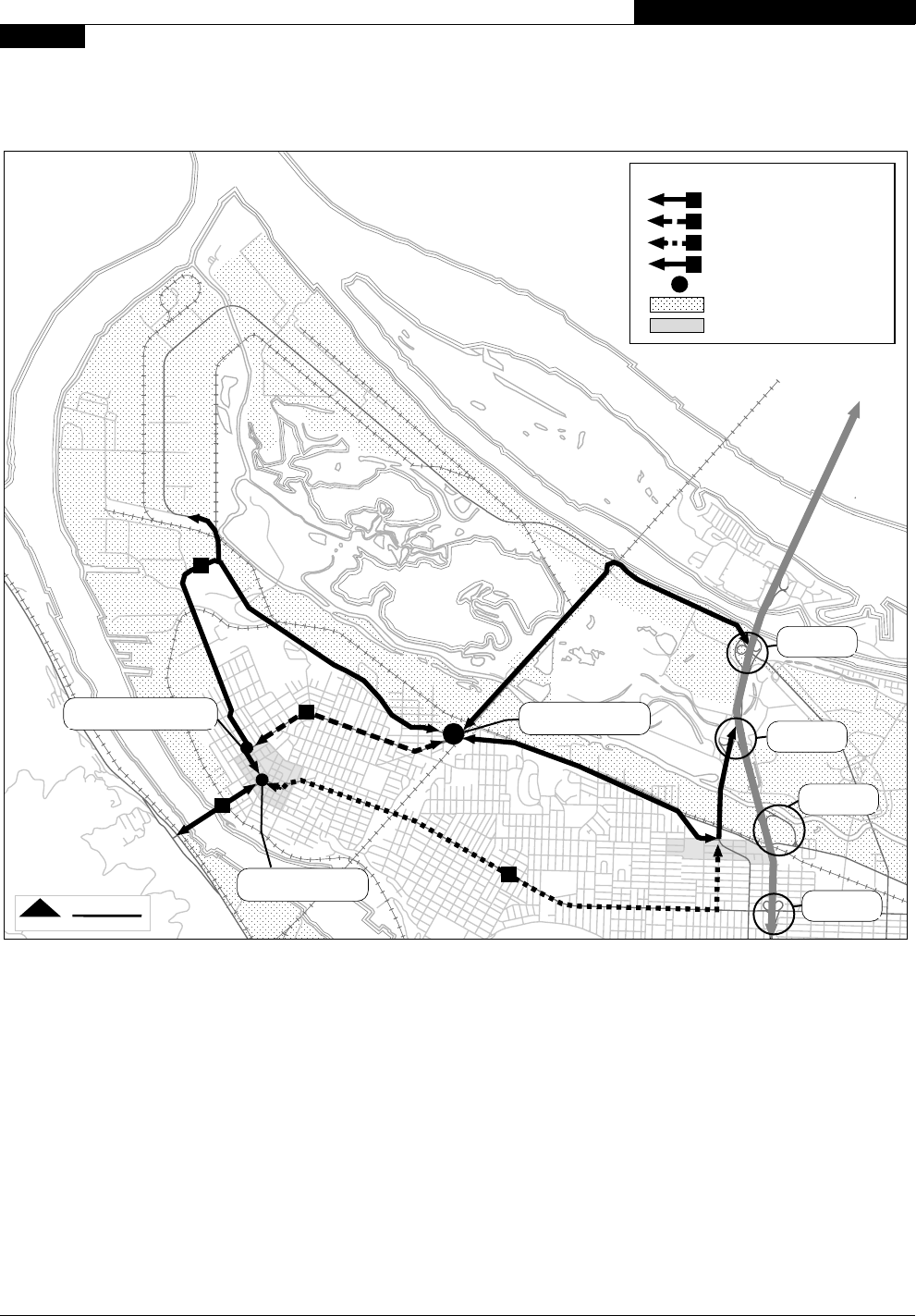
The original action or project alternatives are identified on the following map:

St. Johns Truck Strategy
14
EXECUTIVE SUMMARY & RECOMMENDATION
FIGURE 1
RECOMMENDED PROJECTS MAP
Truck
District
Truck
District
PORTLAND RD
COLUMBIA BLVD.
LOMBARD
S
t Johns
B
ridge
LOMBARD
ST HELENS RD
PORTSMOUTH
W
I
L
L
A
M
E
T
T
E
R
I
V
E
R
FESSENDEN
ST. LOUIS
IVANHOE
SMITH
C
O
LU
M
B
IA
W
A
Y
COLUMBIA BLVD.
MACRUM
PHILADELPHIA
ST. JOHNS
RENO
BURGARD
ROBERTS
T
E
R
M
I
N
A
L
R
D
CHATAUQUA
PENINSULAR
SEVE
R
R
D
N
O
R
T
H
P
O
R
T
L
A
N
D
H
A
R
B
O
R
MIDWAY
George
MS
Roosevelt
HS
Sitton
ES
Pier
Park
Chimney
Park
Smith and Bybee Lakes Park
Cathedral
Park
St Johns
Park
Johnswood
Park
Park
Heron Lakes
Golf Course
West
Delta
Park
P.I.A.
St. Johns
Pedestrian
District
John
ES
HAYDEN ISLAND
1
4
7
2
5
6
3
8
0.5 Mile
SCALENORTH
Taffic Calming and Bicycle/Pedestrian
Safety Projects
Lombard St.
Fessenden St
St. Louis Ave.
Columbia Blvd.
Lombard/St. Louis/Ivanhoe Intersection
Ivanhoe/Philadelphia Intersection
Columbia Blvd/Portland Rd/Columbia Way Intersection
Burgard/Lombard Street Segment
Truck Street
Improvements
5
6
8
1
2
3
4
7

St. Johns Truck Strategy
15
INTRODUCTION
1
CHAPTER 1
WHY STUDY THE COLUMBIA CORRIDOR
AND THE NORTH PORTLAND PENINSULA
The purpose of the Columbia Corridor Transportation Study is to provide a comprehensive vision for
transportation policy and improvements that will serve the diverse uses within the Corridor well into the
21st century. The Columbia Corridor
reaches from the Rivergate Industrial District
on the west to the City of Troutdale on the
east.
The St. Johns Truck Strategy (SJTS), referred
to as the North Portland Peninsula Truck
Circulation Study in the
Columbia Corridor
Transportation Study (City of Portland, Office
of Transportation, 1999) encompasses the
western one-third of the Columbia Corridor
(Figure 2). The SJTS study area specifically
includes all of the North Portland Peninsula
generally west of the Burlington Northern
Rail Road “cut”, a below grade rail corridor, at
N. Carey Boulevard south of N. Columbia
Boulevard, and west of Martin Luther King Jr.
Boulevard, north of N. Columbia Boulevard.
The request for this study came as a result of
the 1992 update of the City’s Transportation
Element of the Comprehensive Plan.
Residents living on the peninsula asked the City to look at ways to reduce or eliminate the impacts of
truck traffic moving to and from the St. Johns Bridge; N. Fessenden Street, among others, was identified as
being adversely impacted by truck traffic.
The SJTS completes the Columbia Corridor Transportation Study’s transportation vision for the entire
corridor. The SJTS portion of this study focuses on:
• Reducing through or non-local truck trips in predominately residential and retail-commercial areas of
the peninsula
• Mitigation of truck impacts
• Designation of truck streets
• Improvement of those streets for both through and local truck trips using the St. Johns Bridge
Mission Statement:
Evaluate and recommend to City Council appropriate transportation solutions that address freight
movement needs of the North Portland industrial areas and protect the St. Johns residential and
commercial hub from through-truck infiltration. The recommended solutions will recognize the
contribution of freight movement to the local, regional and state economies, and that a significant portion
of that freight is moved to and from the industrial areas of North, Northeast and Northwest Portland.
FIGURE 2
M
A
R
T
I
N
L
U
T
H
E
R
K
I
N
G
B
L
V
D
.
COLUMBIA RIVER
W
I
L
L
A
M
E
T
T
E
R
I
V
E
R
STUDY
AREA
COLUMBIA BLVD.
LOMBARD
BNSF RR
I-5 FREEWAY
PORTLAND RD.
ST. HELENS RD.
St. Johns
Bridge
LOMBARD
MARINE DR.

St. Johns Truck Strategy
16
CHAPTER 1
INTRODUCTION
Objectives:
• Identify ways in which truck routing can be improved to and from the St. Johns Bridge, Rivergate
and I-5
• Determine how non-local truck traffic can be eliminated or reduced on residential and retail-
commercial streets
Previously identified alternatives for the efficient movement of trucks, including a reduction in non-local
trucks through neighborhoods include the following ideas:
• Prohibit through trucks on Local Service Streets to reduce truck impacts on the neighborhoods
• Improve the Lombard/Ivanhoe route to make this truck route more efficient
• Consider a new Willamette River bridge between Rivergate and US 30 for truck movement
• Consider creating a new truck route through the Terminal 4 facilities to avoid use of steep residential
streets to access industries along the St. Johns waterfront
Additionally, the City Council determined that the strategy selected will:
• Utilize the existing local and regional street system
• Be a short-term (2-5 year) solution
• Not include more than $10 million in solutions
• Coordinate with other North Portland projects
• Carefully analyze solutions so as to not shift a problem to a different location

St. Johns Truck Strategy
17
EXISTING CONDITIONS
CHAPTER 2
AREA CHARACTER
The study area (Figure 3) is a peninsula, which is defined by the confluence of the Willamette and
Columbia Rivers. Approximately two-thirds of the study area is industrial, and the remaining one-third is
residential and retail-commercial. The study area includes the North Portland Truck District, in turn
including the Rivergate Industrial District, and a small portion of the Columbia South Shore Industrial
District. The St. Johns and Cathedral Park Neighborhoods occupy the remainder of the study area.
Much of the Rivergate Industrial District and the west end of the Columbia South Shore Industrial
District is built on fill (river dredging) in and around the Smith and Bybee Lakes recreation area and the
Columbia River sloughs. The area is flat and low, with occasional stands of Cottonwood and Alder, or
even coniferous trees. The majority of both the Willamette and Columbia River frontages have
traditionally been occupied by river-related industrial uses. More recently, other uses (residential, open
space) have interrupted the industrial dominance. The St. Johns and Cathedral Park area is mostly
developed and urban in character.
LAND USE
A broad range of land use occurs within the study area. Generally, south of N. Columbia Boulevard and
Pier Park, those activities are residential and retail. This area includes the Cathedral Park and St. Johns
Neighborhoods, including the St. Johns Pedestrian District, with a population of approximately 12,000
(1994 statistics, Regional Transportation Model, Transportation Analysis Zone data, Metro, 1999). Retail
employment in the area totals 3,548 jobs (1994). North of Columbia Boulevard and west of Pier Park,
the land uses are industrial and open space, including the Port of Portland’s Terminals 4 and 6, the
Rivergate Industrial District, the Smith and Bybee Lakes open space, Chimney and Kelly Point Parks, and
the Columbia River sloughs. Non-retail jobs in the area numbered 17,796 (1994).
The St. Johns and Cathedral Park neighborhoods are characterized by single-family homes, but multi-
family living is on the increase in the area. Retail-commercial uses are dispersed along N. Fessenden and
Lombard Streets (mostly), and concentrated within the St. Johns Pedestrian District (Downtown St.
Johns).
Large, single-story buildings (warehouses) dominate in the Rivergate Industrial District. The
predominant function is warehousing and distribution. Expansive outdoor work and/or storage areas,
and equipment for loading and unloading ships (docks, cranes, and conveyors) characterize the Port’s
terminals.

St. Johns Truck Strategy
18
FIGURE 3
AREA CHARACTER AND LAND USE
EXISTING CONDITIONS
CHAPTER 2
T-6
T-4
COLUMBIA RIVER
W
I
L
L
A
M
E
T
T
E
R
I
V
E
R
NORTH PORTLAND HARBOR
COLU
M
B
I
A
S
L
O
U
G
H
George
MS
Roosevelt
HS
Sitton
ES
Pier
Park
Chimney
Park
Smith and Bybee Lakes Park
Cathedral
Park
St Johns Park
Park
Kelly
Point
Park
Heron Lakes
Golf Course
West Delta Park
East
Delta Park
P.I.R.
St. Johns
Pedestrian
District
John
ES
EXPO
Park
PORTLAND RD
LOMBARD
St Johns
Bridge
LOMBARD
FESSENDEN
COLUMBIA BLVD.
B
U
R
G
A
R
D
ST. LOUIS
M
A
R
IN
E
D
R
.
LOMBARD
I-5 FREEWAY
ST HELENS RD
U.S. HWY 30
Rivergate
Industrial
District
Cathedral
Park
Neighborhood
Columbia
South Shore
Industrial
District
Marine Dr. Corridor
Colum
bia Corridor
M
.
L
.
K
.
B
L
V
D
.
St. Johns
Neighborhood
Sub-Areas
Terminal
Park /Open Space
School
LEGEND
0.5 Mile
SCALENORTH

St. Johns Truck Strategy
19
TRANSPORTATION NETWORK CHARACTERISTICS
The east-west roadway system in the SJTS study area consists primarily of N. Marine Drive, Columbia
Boulevard, and Fessenden and Lombard Streets. Marine Drive and Columbia Boulevard lie within or
define an edge of the North Portland Truck District. In addition to their inherent status as truck streets,
they are both Major City Traffic Streets. Fessenden Street is a Neighborhood Collector. Lombard Street
(east of St. Johns) is a District Collector. Neither is a designated truck street, but Lombard is designated
as the US 30 Bypass.
While there is at the time of this study no officially designated truck street, or streets, between the
North Portland Truck District and the St. Johns Bridge, the Columbia, Burgard, Lombard, St. Louis, Ivanhoe
combination of streets is presently used as the de facto (northern) truck route. The affected street
segments are designated as Major City Traffic Streets. The northern route serves local and non-local
trucks traveling between N. Columbia Boulevard or Marine Drive, and US 30 on the west side of the
Willamette River. The Marine Drive or Columbia, Portland, Fessenden, St. Louis, Ivanhoe combination of
streets (middle route) is used frequently by non-local trucks traveling across the peninsula. I-5 or
Interstate to N. Lombard Street west into St. Johns (southern route) is also used, but by considerably
fewer trucks.
The existing routes can be described in the following manner:
1. Northern Perimeter Route. The first of two District Objectives for the North District Policies, of the
Transportation Element of the Comprehensive Plan, encourages non-local truck traffic to go around
the residential and retail-commercial areas. The Columbia, Burgard, Lombard, St. Louis, Ivanhoe
combination of streets were designated as truck streets by the City in the 1977 Transportation
Element, and only deleted in 1992 at the request of north Portland citizens, until this study could be
completed. The northern route is identified as a truck route by Metro in the present Regional
Transportation Plan, Interim Regional Freight System Map. This same route is also presently
considered a “connector providing access to a Marine Terminal” by ODOT.
2. Middle Route. The Marine Dr. or Columbia, Portland Rd., Fessenden, St. Louis, Ivanhoe combination
of streets is used mostly by non-local trucks, and provides a quicker and more direct route between
I-5 and the St. Johns Bridge than does the northern route. However, this route goes through the
middle of the St. Johns neighborhood, creating greater conflicts with residences and retail properties
than does the northern truck route.
3. Southern Route. The segment of N. Lombard Street, east from St. Johns, is also used by trucks, but
less frequently because of numerous signalized intersections, narrow lanes and heavier traffic. The
southern route also creates conflict between heavy trucks and residential uses, and an even greater
conflict with retail uses than either of the other routes. However, this route is designated as a part of
the National Highway System (US 30 Bypass).
4. St. Johns Bridge. The location of the St. Johns Bridge requires that trucks using any of the three
routes to access the bridge must enter the St. Johns Pedestrian District, with its mix of residential and
retail-commercial uses.
EXISTING CONDITIONS
CHAPTER 2
St. Johns Truck Strategy
20
FIGURE 4
TRANSPORTATION NETWORK CHARACTERISTICS
EXISTING CONDITIONS
CHAPTER 2
The year 2020 modeling done for this study (St. Johns Truck Strategy Modeling Analysis, City of Portland,
Office of Transportation, 2000) shows that while the volume of trucks will increase by approximately one
and one-half times, these patterns will remain essentially the same, unless significant changes are made.
COLUMBIA RIVER
W
I
L
L
A
M
E
T
T
E
R
I
V
E
R
NORTH PORTLAND HARBOR
LOMBARD
FESSENDEN
LO
M
BARD
CO
LU
M
BIA
BLVD
PORTLAND RD
DENVER
1
2
3
MARINE DR
IVA
N
H
O
E
4
St. Johns
Pedestrian
District
I-5/L
O
M
B
A
R
D
IN
T
E
R
C
H
A
N
G
E
IV
A
N
H
O
E
/P
H
IL
A
D
E
L
P
H
IA
IN
T
E
R
S
E
C
T
IO
N
U.S. HWY 30 - ST. HELENS RD.
I-5/C
O
L
U
M
B
IA
IN
T
E
R
C
H
A
N
G
E
I-5/D
E
N
V
E
R
IN
T
E
R
C
H
A
N
G
E
I-5/M
A
R
IN
E
IN
T
E
R
C
H
A
N
G
E
P
O
R
TL
A
N
D
/C
O
LU
M
B
IA
IN
T
E
R
S
E
C
T
IO
N
INTERSTATE - 5
L
O
M
B
A
R
D
/S
T. LO
U
IS
/IV
A
N
H
O
E
IN
T
E
R
S
E
C
TIO
N
COLUMBIA BLVD
INTERSTATE AVE.
BNSF RR
UP RR
Kenton
Pedestrian
District
Northern Perimeter Route
Middle Route
Southern Route
St. Johns Bridge
Key Intersection
Truck District
Pedestrian District
LEGEND
1
2
3
4
0.5 Mile
SCALENORTH

St. Johns Truck Strategy
21
EXISTING CONDITIONS
CHAPTER 2
TRUCK CHARACTERISTICS
A common question when discussing truck-freight issues is what are these policies and/or regulations
addressing? The Columbia Corridor Transportation Study defines freight movement, in terms of trucks,
as the movement of heavy and medium trucks. Light commercial trucks cannot be distinguished from
private vehicles, so are excluded. Medium trucks include trucks with 2 to 4 axles, and two-axle trucks
with six tires. Heavy trucks include all articulated trucks, trucks with one to three trailer, and/or 3 to 9
axles. This review assumes private vehicle and small truck access should be maintained on all streets, in
keeping with neighborhood needs.
TRUCK EXAMPLES
Large Dump, Heavy Truck Short Container, Heavy Truck
Container, Heavy Truck Combination, Heavy Truck

St. Johns Truck Strategy
22
Garbage Container, Heavy Truck
EXISTING CONDITIONS
CHAPTER 2
7-axle, Heavy Truck
2-axle, Medium Truck 2-axle, Medium Truck
Tri-Met Passenger Van Light Flatbed Truck

St. Johns Truck Strategy
23
ALTERNATIVES
CHAPTER 3
The universe of alternatives selected for consideration did not stop at the mandated short-term solution.
Creating such a list of alternatives included substantial interest in a permanent or long-range solution that
would remove trucks from the St. Johns core area and Pedestrian District, providing an alternative to the
use of the St. Johns Bridge for non-local truck traffic. Both long and short-term projects are included in
the following discussion.
LONG-RANGE ALTERNATIVES
The St. Johns Truck Strategy Advisory Committee notes that the short-term recommendations for
projects address only improvement to the existing situation, which includes inherent conflicts. There is no
short-term solution or easy fix that would separate the existing truck-street choices from the residential
and retail-commercial areas of St. Johns, without a significant impact on freight movement. For many local
as well as non-local truck trips, the St. Johns Bridge provides the most convenient, obvious, and efficient
route between US 30 and the Rivergate Industrial District, Columbia Corridor and I-5.
The conflicts created by the existing choices for truck routes across the peninsula will continue to
worsen as truck trips increase. These conflicts are likely to be solved only through the creation of an
alternative to the present route choices (Figure 5). Such an alternative would necessarily find a way to
separate truck traffic from the St. Johns Pedestrian District. Such a separation, in turn, strongly implies the
creation of an alternative to the use of the St. Johns Bridge for freight movement between US 30 and the
Rivergate Industrial District, Columbia Corridor and I-5.
Directing trucks to use the I-5 Freeway and the Fremont or Marquam Bridges, as the only access to and
from US 30 will create significant inefficiencies for the movement of both local and non-local truck-freight
because of an increase in miles of vehicle travel and travel time. It also means only I-205 would provide a
back up route to the use of I-5, resulting in even greater vehicle miles and travel time for access to US 30.
To provide a complete solution to the conflicts between truck-freight and residential and retail-
commercial uses, separating truck trips from the St. Johns Pedestrian District is essential. Three new
routes have been identified as providing for the desired separation:
1. North Willamette Crossing. Build a bridge between the Rivergate Industrial District and US-30.
This option is currently included in the Regional Transportation Plan Preferred List, for study. This
option has a high potential in terms of capturing the cross-peninsula non-local truck movement on
the peninsula. Travel time analysis indicates that this route would provide competitive trip times with
possible alternatives (St. Johns Truck Strategy: Modeling Analysis, 2000).
2. Burlington Northern Rail Road Bridge. Rebuild and/or modify the Burlington Northern Rail
Road Bridge and the N. Carey Boulevard right-of-way and Rail Road “cut” to accommodate trucks.
This option has the highest potential to capture cross-peninsula non-local truck movement on the
peninsula. Travel time analysis indicates that this route would provide competitive trip times with
possible alternatives (St. Johns Truck Strategy: Modeling Analysis, 2000).

St. Johns Truck Strategy
24
ALTERNATIVES
CHAPTER 3
3. River Road. Construct a riverbank roadway from the Rivergate Industrial District, through Terminal
4, to Swan Island to accommodate trucks. By itself this option will not result in the separation of a
significant number of non-local truck trips from the St. Johns core area and Pedestrian District.
Additionally, a riverbank roadway must overcome several challenges presented by the existing
situation:
• Trucks passing through or around Cathedral Park
• Conflict with railroad and/or port operations
• Existing and proposed river-related development
• Several different ownerships (Port of Portland, Union Pacific, McCormick, EPA, Zidell, University of
Portland, City of Portland, et. al.)
• Potentially conflicting plans for a riverbank greenway trail
• Environmental concerns created by the need for fills, retaining walls, or a bridge structure along
significant portions of the identified riverbank
• Significant portions of the riverbank area are zoned to preserve natural features, discouraging or even
prohibiting development
While the two bridge options include some potential for environmental conflicts, the river road option
displays a low potential to capture any significant truck movement by itself. There is no significant
movement of trucks between the Rivergate and Swan Island Industrial Districts (St. Johns Truck Strategy:
Modeling Analysis, 2000). The potential to capture non-local truck movement is only significant for the
third option when one of the two preceding alternatives is also in place, and a connection between the
“River Road” option and one of these new river
crossings is made.
All three of these options have been
recommended and forwarded to Metro for
consideration under the Regional Transportation
Plan. The Regional Transportation Plan includes a
recommended study to determine the need and/
or appropriate location for a bridge crossing near
the mouth of the Willamette River (See:
Appendix C).
Letters from the two affected neighborhoods
accompanied this recommendation. The St. Johns
Neighborhood Association has gone on record
as rejecting all interim (short-term) actions as
inadequate to the needs of the peninsula and,
instead, have consistently promoted one or some
combination of all the above long-term actions as
necessary. The Friends of Cathedral Park have
also expressed a preference for a long-term
solution, eliminating the movement of non-local
trucks through St. Johns. (See: Appendix C)
A
C
B
St Johns
Pedestrian
District
PORTLAND RD
COLUMBIA BLVD.
LOMBARD
St Johns
Bridge
LOMBARD
U.S. 30 - ST HELENS RD
M
A
R
T
I
N
L
U
T
H
E
R
K
I
N
G
B
L
V
D
I-5 FREEWAY
COLUMBIA RIVER
W
I
L
L
A
M
E
T
T
E
R
I
V
E
R
MARINE DR
GOING
A
B
C
New bridge from Rivergate to U.S. Hwy 30
Redesigned BNSF railroad/truck bridge and new Carey Blvd.
New road around St. Johns with river crossing access.
FIGURE 5
LONG RANGE OPTIONS

St. Johns Truck Strategy
25
ALTERNATIVES
C
HAPTER 3
SHORT-TERM ALTERNATIVES
The selection of a universe of alternatives for consideration (Figure 6), including the previously identified
long-range alternatives, incorporated the following objectives identified in 1992:
• Prohibit through trucks on Local Service Streets to reduce truck impacts on the neighborhoods.
• Improve the Lombard/Ivanhoe route to make this truck route more efficient.
• Consider a new Willamette River bridge between Rivergate and US 30 for truck movement.
• Consider creating a new truck route through the Terminal 4 facilities to avoid use of steep residential
streets to access industries along the St. Johns waterfront.
The prohibition of trucks on Local Service Streets has been considered and included in the possible
bicycle/pedestrian actions, although the Advisory Committee’s interest in improvements was more
focused on discouraging trucks on neighborhood streets, so as not to prohibit local deliveries.
Improvements to the Lombard/Ivanhoe route are proposed. Both a new Willamette River bridge and a
riverfront access to industrial areas, including Terminal 4 were considered and recommendations passed
on to Metro.
The Advisory Committee then added to the universe of alternatives in two ways. First, discussion by the
Advisory Committee, plus the experience and professional expertise of the Bureaus of Transportation
Engineering and Development, and Transportation System Management with similar situations led to the
production of the Problem Statements and Solution Proposals (See: Appendix B), which identified and
explained the majority of the alternatives considered by the Advisory Committee. Secondly, the
Advisory Committee continued to generate totally new alternatives or previously identified alternatives
with a new twist throughout the process.
The alternatives generally fell into five categories, including:
• Pedestrian and bicycle safety
• Neighborhood livability
• Discouragement of non-local truck movement on certain streets or into certain areas
• Consolidation and improvement of non-local truck movement
• Information or directive to truck firms and truck drivers
Forty-seven alternatives were identified for consideration, including:
1. The truck route accessing the St. Johns Bridge should be
located on Lombard/St. Louis/Ivanhoe. (Policy consideration)
2. The truck route accessing the St. Johns Bridge should be
located on Columbia Way/Fessenden. (Policy consideration)
3. Remove Ivanhoe from existing truck route; allow trucks to
access Philadelphia Street/St. Johns Bridge via Lombard.
(Policy Consideration: A.3. Option H, pg 11, Problem Statement
and Solution Proposal)
4. The truck route accessing the St. Johns Bridge should be
located on Lombard, east of St. Johns. (Policy consideration)

St. Johns Truck Strategy
26
ALTERNATIVES
CHAPTER 3
PORTLAND RD
COLUMBIA BLVD.
CO
LU
M
BIA W
CO
LU
M
B
IA W
AY
5. Identify a second (alternative) route for moving trucks
across the peninsula: Fessenden, Smith, Lombard, and other
alternatives. (Policy Consideration)
6. Limit local deliveries to trucks weighing 18,000 lbs. or less;
prohibit heavier trucks except on designated route(s).
(Policy consideration)
7. Request change of US 30 Bypass designation from
Lombard, east of St. John’s, to the recommended truck
route. See 1 - 3, above. (Request through region to National
Highway Administration)
8. Re-align Lombard between St. Johns and St. Louis, shifting
roadway north and east of existing roadway, removing
fronting residential structures, and install a sound wall to
protect remaining residential properties. ($6.38m +/-
40%)
9. Implement signing on I-5 to encourage/require the use of
I-5 for access to US 30 or other west side destinations,
and/or to direct trucks to Columbia Blvd. (Regional Issue:
request to ODOT)
10. Create a full freeway interchange at N. Columbia
Boulevard and I-5. (In Regional Transportation Plan, $70m +/
-)
11. Mandate and fund follow-up, including continuation for
review by the existing committee, to determine the
efficacy of short-term projects. (Study)
12. Consider use of T-2 as a support facility for T-4, T-6,
Rivergate (or other terminals or facilities), barging
deliveries, goods, etc. to these places, eliminating some
quantity of trucks. (See: Letter from Port Marine Division,
Scott Van Wormer)
13. Add ramp from eastbound Columbia Blvd. to northbound
Portland Rd. and prioritize the movement between
Portland Rd. and Columbia Blvd. (A.1., Option A, pg 2, PSSP)
14. Adjust signal timing: lengthen green time on designated
truck routes, shorten signal cycles on non-truck streets,
eliminate signals where possible on truck routes. (A.1.,
Option B, pg 3, PSSP)
15. Install signing at N Portland/N Columbia intersection,
directing trucks to Columbia. (A.1., Option C, pg, 3, PSSP)
16. Designate area truck routes and install directional signing.
(A.1., Option C, pg 3 and Option G, pg 4, PSSP: limited sign
program)
17. Initiate a truck signing program city-wide to provide
identification/direction of appropriate routes (i.e., where
are the truck routes) and discourage non-local truck
movement where inappropriate. (A.1., Option C, pg 3 and
Option G, pg 4, PSSP: city-wide sign program)
18. Add traffic capacity on I-205 through use of permanent
HOV lanes. (A.1., Option D, pg 3, PSSP)
19. Add slip lane from southbound Denver to westbound
Argyle Way (A.1., Option E, pg 3, PSSP)
COLUMBIA BLVD.
DENVER
ARGYLE
INTERSTATE
Improve circulation between Portland Portland Blvd. and
Columbia Blvd. (13)
Signs on I-5 can direct tracks to the preferred route. (9)
Make truck movement easier in places we want them
to be. (19)

St. Johns Truck Strategy
27
ALTERNATIVES
C
HAPTER 3
SAINT L
SAINT L
OUIS
LOM
B
OM
B
ARD
IV
IV
ANHOE
ANHOE
IVANHOE
PHILADELPHIAPHILADELPHIA
IVA
N
H
O
E
A
N
H
O
E
20. Reconfigure I-5 from 3 travel lanes in each direction to 2
travel lanes in each direction with 2 center reversible lanes.
(A.1., Option F, pg 3, PSSP)
21. Redesign/rebuild intersection of Ivanhoe/Lombard/St. Louis
to better accommodate the movement of trucks from
Lombard to Ivanhoe, but restrict truck movement from St.
Louis to Ivanhoe. (A.1., Option H, pg 4, PSSP)
22. Same as above, but remove no housing. (A.1., Option H, pg
4, PSSP)
23. Realign the Philadelphia/Ivanhoe intersection to favor
movement between the St. Johns Bridge and Ivanhoe.
(A.1., Option I, pg 5, PSSP)
24. Remove or replace pedestrian overcrossing on Columbia
Blvd. at Midway. (A.1., Option J, pg 6, PSSP)
25. Replace bridge over the UPRR tracks at Lombard, east of
T-4. (A.1., Option K, pg 6, PSSP)
26. Redesign N Burgard between Columbia Blvd. and Terminal
4 to better accommodate trucks. (A.1., Option L, pg 7,
PSSP)
27. Remove the signal at Argyle St./Interstate Pl. to facilitate
movement on Columbia. (A.1., Option M, pg 7, PSSP)
28. Provide an updated study of a T-4 access road, to identify
access to the St. Johns Bridge with minimum impact to
residential streets. (A.2., Option E, pg 8, PSSP)
29. Reduce or eliminate left turn movements to and from
Columbia Blvd., or design turn pockets to limit long vehicle
access. (A.3., Option A, pg 8, PSSP)
30. Add curb extensions, median islands, traffic circles, or
roundabouts at intersections to limit access of long
vehicles. (A.3., Option B, pg 8, PSSP)
31. Place restrictions on large trucks at Portland Road,
Columbia, Portsmouth intersections to direct trucks to
Columbia Boulevard for east-west movement. (A.3., Option
B, pg 8 and C.1., A, pg 14, PSSP)
32. Add 22-foot (split) speed bumps on Neighborhood
Collector Streets: Columbia Way, Fessenden, St. Louis.
Modifies travel time, especially for longer and heavier
vehicles. (A.3., Option C, pg 9, PSSP)
33. Add 22-foot speed bumps on non-emergency streets:
Fessenden, Columbia Way, Oswego, Columbia Blvd., Smith.
(A.3., Option C, pg 9, of SJTS, PSSP)
34. Change the design of Fessenden to discourage non-local
trucks. (A.3., Options C-F, ppg 9 and 10, PSSP)
35. Reduce posted speed limits on Neighborhood Collector
Streets: Fessenden and St. Louis. (A.3., Option D, pg 9, PSSP:
request to ODOT)
36. Eliminate the right-turn only lane on westbound Columbia
Way to northbound Fessenden. (A.3., Option E, pg 10,
PSSP)
37. Change the appearance and function of certain streets by
reducing the number of through lanes by adding left turn
lanes, bike lanes and parking: Fessenden, St. Louis,
Columbia Way, Macrum. (A.3.,Option F, pg 11, PSSP)
Eliminate truck-attractive right-turn bay on Columbia
Way to Fessenden. (36)
Redesign Philadelphia/Ivanhoe to improve truck
movement. (23)
Resign Lombard/st. Louis/Ivanhoe intersection for truck
and pedestrian movement. (21/22)

St. Johns Truck Strategy
28
ALTERNATIVES
CHAPTER 3
38. Change the allocation of roadway space on Philadelphia
and the St. Johns Bridge to: two vehicle lanes and two bike
lanes. (A.3., Option G, pg 11, PSSP)
39. Modify the existing truck route to have trucks turn off of
Lombard to Ivanhoe at St. Johns, rather than St. Louis.
(Policy consderation: A.3. Option I, pg 11, PSSP)
40. Enforce truck regulations, in concert with education of the
trucking community. (A.3. Option J, pg 11, PSSP)
41. When the St. Johns Bridge is closed for repairs, the choice
of detour routes should be analyzed for the possibility of
designation of a permanent route or routes for trucks, not
including the St. Johns Bridge. (A.3. Option K, pg 11, PSSP)
42. Redesign of N Portland/Marine Drive intersection to
discourage use of N Portland Road. (A.3. Option L, pg 11,
PSSP)
43. Survey Local Service Streets to alter the ability to speed
for all vehicles, through use of 14-foot speed bumps. Some
streets have already been evaluated for this option. (B.1.,
Option A, pg 12, PSSP)
44. Improve safety for pedestrians and bicylists at street
crossings, through the use of medians, curb extensions,
marked crosswalks, bike lanes, and landscaping.
Intersections to consider have been identified. (C.1., Option
A, pg 14, PSSP)
45. Include pedestrian/bicycle safety elements in any
recommendation increasing truck movement along any of
the above routes. (C.1., Option A and C, pg 14, PSSP)
46. Review current Tri-Met bus routes and locations of current
bus stops, for safety and influence on the flow of traffic.
(C.1., Option B, pg 14, PSSP)
47. Install bike lanes where possible on designated bike routes.
(C.1., Option C, pg 14, PSSP)

St. Johns Truck Strategy
29
ALTERNATIVES
C
HAPTER 3
The Problem Statements and Solution Proposals document provides additional information on the
alternatives or aspects of the alternatives, including cost estimates.
The alternatives considered were intentionally conceptual. The specifics of any of the identified projects
will be determined in a subsequent project development phase, in many cases providing for additional
involvement by neighboring property owners or residents.
FIGURE 6
UNIVERSE OF ALTERNATIVES
COLUMBIA RIVER
W
I
L
L
A
M
E
T
T
E
R
I
V
E
R
N
O
R
TH
PO
R
TLAN
D H
AR
BO
R
1
3
4
21,22
8
9
10
13
15
19
20
23
24
25
26
27
28
29,33
32,33,37
2,32,33,34,35,37
32,35,37
33
36
37
39
42
31
PORTLAND RD
COLUMBIA BLVD.
LOMBARD
St Johns
Bridge
LOMBARD
ST HELENS RD
PORTSMOUTH
M
A
R
T
I
N
L
U
T
H
E
R
K
I
N
G
B
L
V
D
I-5 FREEWAY
COLUMBIA RIVER
W
I
L
L
A
M
E
T
T
E
R
I
V
E
R
FESSENDEN
SAINT LOUIS
IVANHOE
SMITH
OSWEGO
COLUMBIA WAY
C
O
LU
M
B
IA
B
L
V
D
.
MACRUM
PHILADELPHIA
SAINT JOHNS
RENO
BURGARD
MARINE DR.
LO
M
BA
R
D
ROBERTS
T
E
R
M
I
N
A
L
R
D
MIDWAY
DENVER.
ARG
YLE
W
AY.
INTERSTATE
UP RR
ARGYLE
0.5 Mile
SCALENORTH

St. Johns Truck Strategy
30

St. Johns Truck Strategy
31
RECOMMENDATIONS
C
HAPTER 4
Starting with the identified universe of alternatives, the SJTS AC developed and applied selection criteria
developing a more defined list for their final consideration. This final list consisted of eight transportation
improvement projects and six other actions, including policy, program and study recommendations.
These recommendations were then further refined, resulting in the following package or set of
coordinated recommendations. This set of recommendations is intended to provide a balanced
approach to the identified issues, providing for both neighborhood livability and safety, and the movement
of non-local trucks.
The recommendations fall into two categories of action, transportation improvements and administrative
recommendations, which include two regulatory actions, three operational directives, and one policy.
TRANSPORTATION IMPROVEMENT PROGRAM
A “package” of improvement projects is recommended. Two categories of improvement are included,
one for traffic calming and pedestrian/bicycle safety improvements, and one for truck street
improvements. The two categories are intended to work together to provide for both improved truck
circulation and mitigation of truck impacts. The first category provides for mitigation of truck impacts,
neighborhood livability and safety for pedestrians and bicyclists. However, the safety and livability
improvements would not, by themselves, reduce the area of impacts from non-local trucks.
The second category provides for improvements on the recommended truck streets to increase the
efficiency of truck movement and to encourage non-local trucks to stay on the designated route.
However, the truck improvements by themselves could result in a greater number of truck trips on the
designated truck streets. Without the recommended bicycle and pedestrian improvements even greater
adverse impact could occur within the residential and commercial/retail areas adjacent to the designated
truck streets.
A stronger emphasis on neighborhood safety provides for pedestrian/bicycle safety and neighborhood
connectivity in the near-term. This focus can (depending on timing) provide mitigation for a potential
diversion of trucks from the Interstate-Max LRT, I-5 Resurfacing and St. Johns Bridge Rehabilitation
projects. It will also provide mitigation for a potential diversion of trucks caused by the truck street
improvement projects recommended by this study.
Traffic Calming/Safety
There are four areas identified as appropriate to receive traffic calming or pedestrian/bicycle safety
improvements (TC/S). The identified areas include:
TC/S Area No. 1: Lombard, Pier Park to St. Louis
TC/S Area No. 2: Fessenden, Columbia Way to St. Louis
TC/S Area No. 3: St. Louis, Fessenden to Lombard
TC/S Area No. 4: Pedestrian and bicycle safety project, Columbia Boulevard

St. Johns Truck Strategy
32
RECOMMENDATIONS
CHAPTER 4
TC/S Area No. 1 (Figure 7): Lombard, Pier Park to St.
Louis Street, is used heavily by trucks, as the most direct
connection between the Rivergate Industrial District and the
St. John’s Bridge. The street is wide and straight, with only a
pedestrian activated signal at Reno St., Pier Park to St. John’s
Avenue. It is not an easy street for a pedestrian to cross.
Reno Avenue, just north of St. John’s, is frequently used by
school age children coming from or going to Sitton School.
Pier Park, a few residences and numerous businesses flank
this segment of the street. At St. John’s Avenue, Lombard
jogs west towards the river approximately one block. From
St. John’s Street to St. Louis Street, Lombard is again straight,
but much narrower and here it is flanked by multi-dwelling
residential uses.
TC/S Area No. 2 (Figure 8): Fessenden Street, from
Columbia Way to St. Louis is a straight and wide street,
frequently used by non-local trucks moving across the peninsula. It is not an easy street for a pedestrian to cross,
even with a pedestrian activated signal at Burr St. However, institutions, schools and shopping encourage street
crossings by all ages.
With a truck-sized right turn bay at the signalized
intersection, trucks from Columbia Way easily access
Fessenden. Fessenden runs without narrowing, or turning
from Columbia Way, on the east, to Charleston Street, on the
west, where it begins curving south, becoming St. Louis. The
use of Fessenden provides the shortest route across North
Portland, between I-5 and US 30. Single and multi-family
residences, institutions and commercial/retail activities lie
adjacent to Fessenden Street.
TC/S Area No. 3 (Figure 9): St. Louis, Fessenden to
Lombard is a wide street with numerous side street
connections, several of which do not connect at right angles.
St. Louis has a sight-obscuring curve on its east end as
Fessenden becomes St. Louis and its width has diminished by
the time it reaches its intersection with Lombard. Institutions,
schools and shopping encourage street crossings by all ages.
TERMINAL
4
LO
M
B
A
R
D
St Johns
Bridge
LOMBARD
W
I
L
L
A
M
E
T
T
E
R
I
V
E
R
FESSENDEN
SAINT LOUIS
IVANHOE
SMITH
CO
LUM
BIA BLVD.
PHILADELPHIA
SAINT JOHNS
ROBERTS
T
E
R
M
I
N
A
L
R
D
RENO
Sitton
ES
Pier
Park
Chimney
Park
Cathedral
Park
St Johns
Park
Johnswood
Park
John
ES
St. Johns
Pedestrian
District
0.25 Mile
SCALE
NORTH
St. Johns
Pedestrian
District
LOMBARD
FESSENDEN
SAINT LOUIS
IVANHOE
SMITH
COLUMBIA WAY
COLUMBIA BLVD.
MACRUM
A
CHARLESTON
George
MS
Roosevelt
HS
Pier
Park
St Johns
Park
Johnswood
Park
George
Park
John
ES
Northgate
Park
0.25 Mile
SCALE
NORTH
WILLAMETTE
RIVER
TERMINAL
4
St. Johns
Pedestrian
District
LOMBARD
St Johns
Bridge
LOMBARD
FESSENDEN
SAINT LOUIS
IVANHOE
SMITH
COLUMBIA BLVD.
PHILADELPHIA
SAINT JOHNS
ROBERTS
RENO
CHARLESTON
SENECA
SENECA
George
MS
Roosevelt
HS
Sitton
ES
Pier
Park
Cathedral
Park
St Johns
Park
Johnswood
Park
George
Park
John
ES
0.25 Mile
SCALE
NORTH

St. Johns Truck Strategy
33
RECOMMENDATIONS
C
HAPTER 4
TC/S Area No. 4 (Figure 10): Columbia
Boulevard is designated and serves as the major truck
street to the Rivergate Industrial District and Terminal 4.
From Portland Road to Burgard Road Columbia is
flanked on its north side by (mostly) industrial and
business activities. However, the south side of Columbia
is dominated by residential uses. Access to the local
service streets on the south side is virtually unlimited and
occasionally used by trucks to access Fessenden Street.
Street Segment Nos. 1 through 3, in the Traffic
Calming/Safety category, would be evaluated for
improvements that would increase pedestrian
access and neighborhood connectivity. Such
improvements could include lane restriping, curb
extensions, pedestrian refuges, and perhaps medians
in the curves, such as at St. Johns Avenue at
Lombard or Seneca at Fessenden. The local residents would evaluate the use of speed bumps.
Signalization, to provide more frequent, safer opportunities for street crossings, could also be timed to
provide a continuous progression for vehicles, while controlling speed.
For Columbia Boulevard (Street Segment No. 4), improvements would be employed to provide access
across the street, improved safety and convenience for pedestrians and bicyclists. Such improvements
could be accomplished through the provision of bike facilities on, and pedestrian/bicycle access across
Columbia, potentially including curb extensions, pedestrian refuges, median barriers (to restrict left turn
movements for long vehicles to Local Service Streets to the south) and mid-block pedestrian crossings.
Implementation of these concepts would entail a more detailed, closer look at the options for
improvement, including engineering analysis, and additional citizen involvement.
Costs associated with the
identified Traffic Calming/Safety
Improvements could change with
additional local review of the
proposed concept. However,
these figures include a 40%
contingency:
COLU
M
B
I
A
S
L
O
U
G
H
PORTLAND RD
COLUMBIA BLVD.
LOMBARD
PORTSMOUTH
W
I
L
L
A
M
E
T
T
E
R
I
V
E
R
FESSEND
EN
ST. LOUIS
IVANHOE
COLUMBIA WAY
COLUMBIA BLVD.
M
AC
RU
M
S
CHATAUQUA
PENINSULAR
N
O
R
T
H
P
O
R
T
L
A
N
D
H
A
R
B
O
R
M
ID
W
AY
George
MS
Roosevelt
HS
Sitton
ES
Pier
Park
Chimney
Park
Smith and Bybee Lakes Park
Cathedral
Park
St Johns
Park
Johnswood
Park
Park
Heron Lakes
Golf Course
West
Delta
Park
P.I.A.
John
ES
HAYDEN ISLAND
0.5 Mile
SCALE
NORTH
TABLE 1
Street Segments
Nos. 1-3
Street Segments
Nos. 2-3
Street Segment
No. 4
Street Segment
No. 4
Implement Traffic
Calming Projects
Bikelanes, Medians,
New Pavements
Markings, and Curbs
Replace Midway
Pedestrian Crossing
Left Turn Controls:
Chatauqua,
Portsmouth,and
Penninsular
Costs included in
construction estimates
$ 862,045.37
$ 224,553.22
$ 51,094.91

St. Johns Truck Strategy
34
RECOMMENDATIONS
CHAPTER 4
Truck Street Improvements
There are three intersections and one street segment identified to receive improvements related directly
to the ease and efficiency of truck movement. The identified areas are:
TSI No. 1: Lombard/St. Louis/Ivanhoe, intersection
TSI No. 2: Ivanhoe/Philadelphia, intersection
TSI No. 3: Columbia/Portland, intersection
TSI No. 4: Burgard and Lombard, streets segment, from the Columbia/Lombard intersection and
entrance to Rivergate, to the intersection of Lombard/Terminal Road
TSI Area No. 1 (Figure 11): The Lombard/St. Louis/
Ivanhoe “intersection” actually consists of two intersections,
Lombard/St. Louis and St. Louis/Ivanhoe. However, past
improvements have acted to de-emphasize the east side of
the St. Louis/Ivanhoe intersection, emphasizing the turn
movement from St. Louis to Ivanhoe and vice versa, creating
a through movement for this turn, in both directions. This
compound intersection, including the light at Lombard/St.
Louis, is a place where trucks, cars, bicycles and pedestrians
come into conflict.
Redesign of this intersection could, but would not necessarily,
include:
• Realignment of some portion of the intersection, which
in turn, could include purchase of additional right-of-way.
• Realignment of travel lanes, which could but would not
necessarily include purchase of additional right-of-way or
limited removal of on-street parking.
• New signal or signal phasing, which could include a pedestrian only phase.
• Median(s), making pedestrian crossings more convenient.
TSI Area No. 2 (Figure 12): The Ivanhoe/Philadelphia
intersection is the entrance/exit from the east end of the St.
Johns Bridge. Past improvements have attempted to slow
and control traffic to allow Philadelphia and Lombard to be
less of a barrier for pedestrians. However, this extremely
complex intersection can be confusing to anyone not already
familiar with it, and the present configuration and signalization
can result in long lines of vehicles waiting to pass through it,
without providing a clear and convenient route for pedestrians.
Redesign of this intersection could include, but would not
necessarily be limited to:
• Realignment of travel lanes, which could but would not
necessarily include the addition of a median or medians
to direct vehicles.
• New sidewalks and curbs.
• New signal or signal phasing, emphasizing the connection
between Ivanhoe and the bridge, particularly for trucks.
LOMBARD
St Johns
Bridge
LOMBARD
W
I
L
L
A
M
E
T
T
E
R
I
V
E
R
FESSENDEN
SAINT LOUIS
IVANHOE
SMITH
LUM
BIA BLVD.
PHILADELPHIA
SAINT JOHNS
ROBER
TS
RENO
Sitton
ES
Pier
Park
Cathedral
Park
St Johns
Park
Johnswood
Park
John
ES
St. Johns
Pedestrian
District
TERMINAL 4
0.25 Mile
SCALE
NORTH
LOMBARD
St Johns
Bridge
LOMBARD
W
I
L
L
A
M
E
T
T
E
R
I
V
E
R
FESSENDEN
SAINT LOUIS
IVANHOE
SMITH
PHILADELPHIA
SAINT JOHNS
RENO
Roosevelt
HS
Sitton
ES
Cathedral
Park
St Johns
Park
Park
John
ES
St. Johns
Pedestrian
District
TERMINAL
4
0.25 Mile
SCALE
NORTH

St. Johns Truck Strategy
35
RECOMMENDATIONS
C
HAPTER 4
TSI Area No. 3 (Figure 13): The Columbia/Portland
intersection provides for connection of the industrial lands
and uses north of Columbia Boulevard to Columbia
Boulevard, via Portland Road. The existing improvements
encourage a westbound straight-through movement, under
Columbia, from Portland Road to Columbia Way. The ease
of access afforded encourages trucks to use Columbia Way
to access Fessenden and St. Louis Streets, directly through
the middle of the neighborhood. While signing is provided
that identifies access to Columbia as the way to Terminal 4
and Rivergate, there is no information about which route
trucks should use to access the St. Johns Bridge and US 30.
Redesign of this intersection could include, but would not
necessarily be limited to:
• Realignment of travel lanes emphasizing the connection
between Columbia Boulevard and Portland Road for
trucks and/or specifically discouraging trucks from using
Columbia Way
• New signal and/or signing, emphasizing the connection between Portland Road and Columbia Boulevard for
trucks and/or specifically discouraging trucks from using Columbia Way
• New sidewalks and curbs
• New medians channeling traffic in the appropriate
directions
TSI Area No. 4 (Figure 14): The Burgard/Lombard
combination of street segments includes two 90 degree
turns and several intersections (Lombard Street and
Rivergate Boulevard into the Rivergate Industrial District, and
Sever and Terminal Roads into the Terminal 4 area), and at
one driveway that experiences heavy truck traffic
(Northwest Container Services, Inc.). It also includes a
narrowing of the roadway and a change in the number of
travel lanes as the road makes a 90 degree turn, changing
from Burgard to Lombard. The intersection of Columbia
Boulevard with Lombard Street, the main entrance to the
Rivergate Industrial District, has been recently reconstructed
and is signalized. The intersection of Terminal Road with
Lombard/Burgard can be a bottleneck despite existing
signalization.
C
O
L
U
M
B
I
A
S
L
O
U
G
H
SMITH LAKE
PORTLAND RD
D
PORTSMOUTH
FESSENDEN
SMITH
COLUMBIA W
AY
COLUMBIA BLVD
MACRUM
MIDWAY
George
MS
Roosevelt
HS
George
Park
Northgate
Park
0.25 Mile
SCALE
NORTH
COLUMBIA SLOUGH
WILLAMETTE RIVER
T4
LOMBARD
COLUMBIA BLVD.
BURGARD
ROBERTS
T
E
R
M
I
N
A
L
R
D
SEVER RD
LOMBARD
RIVERGATE BLVD
TERMINAL
4
RIVERGATE
Northwest
Container
Services, Inc.
Sitton
ES
Pier
Park
Chimney
Park
Johns
0.25 Mile
SCALE
NORTH

St. Johns Truck Strategy
36
RECOMMENDATIONS
CHAPTER 4
Costs associated with the identified Truck Street Improvements could change with additional local review
of the proposed concept. However, these figures include a 40% contingency:
ADMINISTRATIVE RECOMMENDATIONS
The Advisory Committee has considered six administrative recommendations or directives to the
Portland Office of Transportation. Two regulatory recommendations would require further study and
staff action to assess the appropriate manner of implementation. Three new operational directives are
recommended. One policy is recommended.
Of the regulatory actions considered by the Advisory Committee, one would limit local deliveries to
vehicles with no more than 18,000 lbs. gross vehicle weight (GVW), and a second would investigate the
present practices for the movement of hazardous materials, potentially affecting routing and delivery.
Three recommendations are made affecting the operational or organizational aspects of the Portland
Office of Transportation. A study is recommended that would be a follow-up study or continuation of
the SJTS, to ascertain the effectiveness of implemented recommendations. The second operational
recommendation would create a program for education and enforcement of truck regulations, including
providing a “point-of-contact” for both industry and citizens. The third recommendation would establish
a program to inventory, review, design, place and maintain signs for truck traffic.
Lastly, one new policy has been recommended. The policy would establish designated truck streets (a
route) for trucks traveling between the St. Johns Bridge and the I-5 Freeway, between the northwest
industrial districts and the north and northeast industrial districts.
TABLE 2
Intersection No. 1
(Lombard/St. Louis/
Ivanhoe)
Intersection No. 2
(Philadelphia/
Ivanhoe)
Intersection No. 3
(Columbia/Portland/
Columbia Way)
Intersection No. 4
(Burgard and
Lombard from
Columbia to
Terminal Road)
Signalization, Curbs
and Sidewalks, Median,
and Paving
Signalization, Curbs
and Sidewalks, Median,
and Paving
Signalization, Curbs
and Sidewalks, Median,
and Paving
Signalization, Curbs
and Sidewalks, and
Paving
$ 978,947.68
$ 106,904.25
$ 703,000.86
$3,838,968.92

St. Johns Truck Strategy
37
RECOMMENDATIONS
C
HAPTER 4
Load Limit
No action is recommended, at this time. Not enough information is available to fully understand the
consequences of such an action.
A city-wide18,000 lbs. GVW limitation on local deliveries has been recommended as one way to reduce
the adverse impacts of trucks on neighborhoods or other sensitive areas. In effect, heavy trucks and
some medium sized trucks would not be allowed for local deliveries. Non-local trucks would continue
to be regulated as they are now, and would be directed to regional truck routes.
A reduction in the size of vehicles for local deliveries would significantly reduce the impacts of trucks,
inasmuch as those impacts are related to size. Less road wear on the local street system would occur
and some reduction in noise could occur, on a per truck basis. The intimidation factor of trucks, which
can be very much larger than passenger vehicles and even more disproportionate relative to pedestrians,
would also be reduced.
There is also a potential for negative impacts from such a limitation. The full scope of which would
require further study to fully identify. More deliveries, using more medium and light trucks would be just
one of the results of a weight limit on local deliveries. An unknown number of local service providers
would be directly affected in the way they do business. Trucks in excess of 18,000 lbs. GVW are now in
daily use to make fuel deliveries to gas stations, heating oil deliveries, garbage collection, most deliveries
to retailers, and UPS deliveries. Trucks in excess of 18,000 lbs. GVW may also dominate other common
local deliveries, as yet unidentified.
TABLE 3
The Gross Vehicle Weight of Some Potentially affected Vehicles,
for Comparison Purposes Only
UPS Delivery (single axle)
Home Heating Oil Delivery
Tri-Met Bus (40-foot, single axle)
Garbage Collection (compactor equipped)
Garbage Collection (dual wheeled, single axle pickup)
10,000 to 18,000 lbs. *
36,000 to 52,000 lbs. *
37,972 lbs.
50,000 lbs. (32,000 lbs. empty)
8,6000 lbs.
* A range of GVW is given to include the variety of trucks performing this service.
The range given may not include every truck used for these purposes, it is given
only to indicate the typical weight range of that category of truck.

St. Johns Truck Strategy
38
RECOMMENDATIONS
CHAPTER 4
What would be the result of using smaller trucks? Gasoline delivery to service stations can be used as a
very general example. A heavy truck with two trailers is the typical method of delivery of gasoline to
service stations. Such trucks weigh in at up to 105,000 lbs. GVW and carry 11,000 gallons of gasoline.
However, if trucks in excess of 18,000 lbs. are prohibited a service station will need to receive more
deliveries, keeping in mind that in each truck load a significant percent of the weight is the truck itself.
Smaller trucks also have a higher truck to load total weight ratio. Delivery with smaller trucks comes
with the following concerns:
• Increased exposure to unloading activities at the delivery site (noise, light, smell, safety), the impacts
will occur over a greater number of events.
• Increased vehicle miles of travel, although trucks are exempt from regional and state requirements to
reduce VMT there would still be an increase in the number of trucks, the number of truck trips and
the vehicle miles of travel.
• Increased fuel, labor and transshipment costs.
• Similar changes would happen at virtually all service stations and in every other situation (more or
less) that would limit trucks to 18,000 lbs. GVW for local deliveries where a larger truck is now being
used.
There would be substantial costs to be incurred by many private trucking firms, such as the purchase of
new trucks, redistribution of loads from out-of-area heavy trucks to lighter trucks, and not least, more
drivers and load handlers. Intermodal facilities would need more land and/or
expanded truck facilities, and additional land would be needed for the transfer
and redistribution of goods from truck-to-truck for Portland deliveries. The full
economic impact to local firms and to Portland’s distribution economy is
unknown.
Lastly, an attempt by the State of New Jersey to relegate all heavy and non-
local trucks to regional truck routes has resulted in litigation by representatives
of the trucking industry. The Federal Highway Administration believes that the
State of New Jersey will be unsuccessful and have their recent regulation
overturned in court. (See: Appendix C)
Hazardous Materials Study
No action is recommended; the City does not regulate the movement of hazardous materials.
One Advisory Committee recommendation was for a review and analysis of the methods of handling,
sizing and routing hazardous materials. However, the City does not control the movement of hazardous
materials. Hazardous materials are defined and regulated by the federal government (CFR 49-100 to
CFR 49-177). The federal government also controls the movement of, and regulates the packaging and
labeling of hazardous materials. Regulations are applied based on the nature and quantity of hazardous
materials.
Other regulations for the movement of hazardous materials are applied by the State of Oregon, including
prohibition of access in specific situations presenting a hazard to essential roadways, such as the I-26
(Sunset) Tunnel, and the railroad crossing near NW Balboa and US 30.
WEIGHT
LI
M
IT
9
TONS
WEIGHT
LI
M
IT
9
TONS
WEIGHT
LI
M
IT
9
TONS

St. Johns Truck Strategy
39
RECOMMENDATIONS
C
HAPTER 4
The City of Portland regulates the manufacture and storage of hazardous materials through Chapters
33.140, Employment and Industrial Zones, and 33.840, Hazardous Substances Review.
Follow-Up Study
A continuation of the St. Johns Truck Strategy Advisory Committee is recommended to provide review
of the implementation of the recommendations. The affected parties, citizens, businesses and truck-
related firms, represented on the AC, should be included in assessment of the effectiveness of the
implemented short-term responses.
The concern and dedication of the SJTS AC members to resolving these issues would provide a valuable
and informed body of advisors. However, the next phase of development, further definition of as yet
conceptual recommendations, particularly in the realm of traffic calming and pedestrian and bicycle safety
is typically reviewed and discussed with the nearby residents and property owners who will be most
affected. Re-initiation or continuation of this committee, in whole or in part, to oversee the impacts of
implemented projects, would not necessarily conflict with the standard procedure of involving the nearby
residents and property owners in project development.
Education and Enforcement
A program is recommended to provide truckers, trucking-related firms, neighbors, and other interested
parties with a point of contact for trucking-related activities. This program would provide for information,
education, and enforcement. All the recommendations will work better with some level of enforcement.
And, enforcement is less than satisfactory when there is a lack of information by which to make the right
decisions.
The Portland Office of Transportation and other agencies already perform many of the envisioned
functions, including:
• The Traffic Investigations Section of the Operations Division of the Bureau of Transportation System
Management of the Portland Office of Transportation presently provides coordination of certain
trucking activities such as information on appropriate routing for oversized or overweight trucks.
However, this function is being consolidated by ODOT to streamline the permitting system for
oversized or overweight trucks moving within or through the State of Oregon. The new ODOT
permit system provides for continuous operation variance permits like those for trucks over 50 feet
in length. The individual road authorities still issue permits for single trips by vehicles that are over
dimension because they are carrying loads too large in size or weight to reduce to a legal size. This
bureau also provides for and regulates on-street truck parking and loading, including special permits.
• The Bureau of Transportation Engineering and Development provides for and includes consideration
of trucks, where appropriate, in the design, construction and repair of transportation facilities.
• The Transportation Planning Section of the Office of the Director is responsible for writing, updating
and administering the policies of the Transportation Element of the Comprehensive Plan, and the
Transportation System Plan (scheduled for adoption in July 2001), including truck-related policies and
objectives.
• Except for street name signs, which are the responsibility of the Bureau of Maintenance, Traffic
Operations, through the Traffic Investigations Section and the Parking Control Section, provide for all
new or changed signs in the City of Portland.

St. Johns Truck Strategy
40
RECOMMENDATIONS
CHAPTER 4
• The Bureau of Maintenance installs and maintains both general traffic and truck signs.
• The Bureau of Police provides for enforcement of all traffic regulations, including those applying
to trucks.
• The State of Oregon’s Public Utility Commission and State Police regulate many aspects of trucking
activity, including licensing, permits, inspection and enforcement on State Highways.
One centralized point-of-contact for all or virtually all trucking-related concerns and inquiries would
provide better service for these interests than is now available. In all, there is significant expertise
available to the citizens and truckers, but no one “point-of-contact” where a person may access the
information and resources available. With no cross-referenced information or referral available, the right
place to call and the right person to talk to is not clear. The proposed program would correct that by
making the association of these related services more formal.
Not all of the pieces are in place. There is no specific education or outreach function for trucking-related
concerns. There is no mechanism or formally recognized program in place to bring these varied
functions together and coordinate their administration. The cost of such a program would not likely be
great with most of the elements already in existence.
Signing
A city-wide truck signing program is recommended. This program would provide identification of truck
routes that would run primarily on designated Major Truck Streets and direct non-local trucks to those
streets, when a Regional Truck Route is not available. Liaison with the Federal Highway Administration,
ODOT and the Washington Department of Transportation would provide for new or corrected signs on
the state and federal highways. A particular interest has been identified for new signs on I-5 and US 30,
to direct non-local trucks to appropriate route(s) through and/or to North and Northeast Portland.
Planning designations (i.e. Major Truck Street, Minor Truck Street) are defined by trip ends, and
the desired operation of a street, but not necessarily to the present operational characteristics of a
street. For example, N Portland Boulevard is a Major Truck Street, and N Lombard Street is a Minor
Truck Street. But, it is possible that in the future, a “truck route” might run on Lombard rather than
Portland. The concept of a “truck route”, which can run on a series of linked streets, may have
sufficient merit to warrant consideration for official recognition.
Truck routes as described above could have logical names that would add to their utility. For
example, the “Rivergate Truck Route” would give a strong indication of the intended purpose of the
route.
Investigation of the truck-related signs in North and Northeast Portland revealed a number of signs that
are no longer accurate and places where new signs should be provided. As an example, signs for trucks
southbound on Portland Road identify Columbia Boulevard westbound as the way to Rivergate and
Terminal 4, but do not direct non-local trucks to that preferred and designated truck street. Many of the
non-local trucks reaching this intersection proceed straight under Columbia Boulevard to Columbia Way
and Fessenden Street.

St. Johns Truck Strategy
41
RECOMMENDATIONS
C
HAPTER 4
While it is recognized that signs alone may not result in all truck traffic using the appropriate streets, it is
also true that at this time the information provided by signs is not complete, nor in all cases accurate. All
the necessary elements (design, construction, installation, maintenance) are in place to provide new and/
or corrected signs, locally and at the state and federal levels. This program would initiate a priority effort
and coordination of signs.
This recommended program could be included as an element of the recommended Education and
Enforcement Program, it could be a recognized priority within the existing Office of Transportation
organization, or a stand-alone program could be initiated.
Designate Truck Streets
The combination of N. Lombard and Ivanhoe Streets and St. Louis Avenue, between N. Columbia
Boulevard and Philadelphia Avenue are recommended for designation as Major Truck Streets (Figure 15).
These same streets were designated as Major Truck Streets prior to the 1992 update of the
Transportation Element. Use of these streets by heavy trucks and non-local trucks would be
encouraged. Such a designation would comply with the Regional Freight System map of the Regional
Transportation Plan. These street segments still provide for most trucks between Rivergate and
Columbia Boulevard and the St. Johns Bridge. As improvements occur they would specifically be
designed to accommodate truck traffic.
A single, designated route for trucks will reduce the area of truck impacts on the St. Johns
Neighborhood. Presently, there are three commonly used routes for trucks crossing the peninsula:
1. North Columbia Boulevard or Marine Drive to Lombard, St. Louis, Ivanhoe and Philadelphia, the
recommended route;
2. North Columbia Boulevard or Portland Road to Columbia Way, Fessenden, St. Louis, Ivanhoe and
Philadelphia, the fastest route; and
3. North Columbia Boulevard and Portsmouth or I-5 to Lombard and Philadelphia.
There will be an increase of trucks and truck impacts on the chosen streets. Recommended
improvements, such as coordinated traffic signals, improved pedestrian crossings and pedestrian
environment, and street improvements specifically designed to accommodate trucks, will make the flow
of truck traffic more efficient and provide mitigation for the increase in truck trips.
There is no additional fiscal cost to the implementation of this recommendation, except inasmuch as the
designation will indicate the need for any improvements to take into account the needs of truck travel.

St. Johns Truck Strategy
42
RECOMMENDATIONS
CHAPTER 4
FIGURE 15
DESIGNATED TRUCK STREETS
COLUMBIA RIVER
W
I
L
L
A
M
E
T
T
E
R
I
V
E
R
N
O
R
T
H
P
O
R
T
L
A
N
D
H
A
R
B
O
R
PORTLAND RD
COLUMBIA BLVD.
LOMBARD
St Johns
Bridge
ST HELENS RD
M
A
R
T
I
N
L
U
T
H
E
R
K
I
N
G
B
L
V
D
I-5 FREEWAY
IVANHOE
COLUMBIA BLVD.
PHILADELPHIA
BURGARD
R.
INTERSTATE
LOMBARD
ST. LOUIS
Recommended Truck Classification
Major Truck Street Regional Truck Route
Major Truck Street
Minor Truck Street
Truck District
Existing Truck Classifications
0.5 Mile
SCALENORTH

St. Johns Truck Strategy
43
CITIZEN INVOLVEMENT
C
HAPTER 5
In this section, the citizen involvement process and actions will be identified through the following
sections:
• Summary
• Background/City Council mandate
• The advisory committee
• Open houses/information fair
• Notification
• Neighborhood and interested parties, outreach
• Coordination with affected jurisdictions
SUMMARY
Initiation of this study occurred during the 1991-1992 update of the Transportation Element. Citizen
concerns expressed at that time resulted in the mandate for a study to improve truck circulation in the
North and Northeast Transportation Districts. The impacts created by trucking and ways to mitigate
those impacts, particularly on residential and retail-commercial uses, were identified as essential parts of
the study.
Upon initiation of the St. Johns Truck Strategy, an 18 person advisory committee was formed. A
combination of the traditional technical and citizen advisory committees brought together technical
expertise from the city and other affected agencies, neighborhood knowledge, and liaison to the affected
neighborhood and business associations, trucking industry, and the affected jurisdictions. A difficult and
persistent conflict between the representatives to the Advisory Committee surfaced early and was
apparent throughout the study. This conflict arose between those that felt an improvement or mitigation
of truck circulation impacts was both possible and appropriate and those that felt only elimination of
trucks and their impacts was acceptable. The conflict was not resolved by the Advisory Committee, and
a minority of the citizen representatives remained opposed to any alternative that did not result in
removal of truck traffic from St. Johns.
Two open house community events occurred in St. Johns, with this project featured. Participation in the
Columbia Corridor Association’s Information Fair helped to increase and broaden the awareness and
familiarity with the issues and proposed solutions. Notification of the second open house included over
26,000 addresses in the 97203 and 97217 zip code areas.
The affected neighborhoods were either represented on the Advisory Committee, kept informed
through a designated liaison, or both. Several truck-related interests were contacted and kept informed,
in addition to those serving on the Advisory Committee.
Presentations of progress were made to affected neighborhood associations and trucking firms, and to
the North Portland Neighborhood Chairs, through the North Portland Neighborhood Services Office.

St. Johns Truck Strategy
44
CITIZEN INVOLVEMENT
CHAPTER 5
BACKGROUND/CITY COUNCIL MANDATE
The request for this study came as a result of historic truck circulation and access impacts on the
commercial property owners and tenants in the St. Johns and Cathedral Park neighborhoods and the St.
Johns Pedestrian District. Their request to look for solutions to these problems was brought before the
City Council as a part of public hearings on the update of the Transportation Element of the
Comprehensive Plan in 1992. In response to these concerns the Council directed that the Office of
Transportation look at methods in the Columbia Corridor, including the North Portland peninsula, to
improve freight movement around residential and business neighborhoods, thus protecting them from
non-local truck traffic intrusion.
ADVISORY COMMITTEE
The makeup of the Advisory Committee was decided on the basis of being able to exchange important
information directly and without delay between the citizens and business persons living or working in St.
Johns, the affected government agencies and representatives of the trucking industry. One citizen and
one trucking industry representative (Ron Hernandez and Wayne Plaster, respectively) jointly chaired the
Advisory Committee. Citizen and business representation included representatives from the St. Johns
Neighborhood Association, Friends of Cathedral Park, University Park Neighborhood Association, the St.
Johns Business Boosters, the North Portland Transportation Committee (previously active), and citizens
“at large”. Government participation included the City of Portland, Port of Portland, Metro and the
Oregon Department of Transportation. The trucking industry presence included operators of
intermodal facilities, trucking firms and a Portland State University Professor, with expertise in truck-
freight needs and impacts. Additionally, adjacent and nearby neighborhoods were kept informed of
Advisory Committee activities and progress, including the Linnton Neighborhood Association and the
Community Association of Portsmouth. Frequent attendance by representatives of the North Police
Precinct provided yet additional insights.
A total of 18 people agreed to participate in the Advisory Committee. The Advisory Committee
consisted of six citizen and business representatives, five trucking representatives, four City of Portland
representatives and three representatives of other government agencies. See the Advisory Committee
membership list in the front of this document.
The first Advisory Committee meeting was held April 19, 1999. Meetings were held monthly through
June 2000, except for December 1999. All meetings were opened at 4:00 PM at the Bureau of
Environmental Services’ Water Pollution Control Laboratory, located beneath the St. Johns Bridge. In all,
the Advisory Committee met 14 times.
The Advisory Committee decided early in the process that their decisions were to be made by “general
agreement”. However, the level of disagreement experienced within the group resulted in the need to
vote to make certain decisions. For instance, the narrowing process from the universe of alternatives to
those included in the final recommendations was a series of selections or votes by the individual
committee members’ for their favored alternatives. (See: Appendix B)

St. Johns Truck Strategy
45
CITIZEN INVOLVEMENT
C
HAPTER 5
The Advisory Committee members were given an “Exit Survey” by which to comment on the process.
Only three of these surveys were returned, but all three were overwhelmingly positive in their
assessment of the process.
OPEN HOUSES/INFORMATION FAIR
Two City/Port sponsored Open Houses were held to provide information to interested parties in the St.
Johns area. The SJTS draft recommendations were also presented at the Columbia Corridor
Associations’ Information Fair.
Open House No. 1
The first Open House was held on March 15, 1999, from 5:00 PM to 7:00 PM, in the St. Johns
Community Center. Government agencies, affected or surrounding neighborhoods and business
associations, known interested parties, and trucking or truck-related firms were provided notice of this
first Open House. There were 19 visitors who signed in and/or expressed an interest in participating or
at least being informed about the progress and results of the study. The 19 visitors represented a fair
cross-section of those notified.
Information presented at the first Open House included, but was not limited to:
• SJTS Overview (Hand Outs)
• SJTS Mission Statement (Hand Outs)
• SJTS Issues (Hand Outs and Display)
• SJTS Alternatives (Hand Outs and Map)
• North Portland Projects (Hand Outs)
• North Portland Assets and Resources (Hand Outs)
The first SJTS Open House also provided an opportunity for the Portland Bureau of Parks and
Recreation to present information on a study of the feasibility of a recreational trail along the east bank
of the Willamette River.
Columbia Corridor Association’s Information Fair
This annual event, sponsored by the Columbia Corridor Association, was held on May 5, 2000, from
11:00 AM to 2:00 PM, in the Airport Holiday Inn’s Conference Center. Dozens of interests (54
presenters) presented information on their services, products and projects, including government
agencies, manufacturers, suppliers, distributors and private consultants. There were over 230 people in
attendance. The St. Johns Truck Strategy staff presented information on the projects and programs being
considered by the Advisory Committee. The Columbia Corridor Association provided notification and
promotion of the event.
Open House No. 2
The second Open House, held on May 6, 2000, from 1:00 PM to 4:00 PM, in the St. Johns Community
Center, provided information on the policies, programs and projects being considered by the Advisory
Committee. In addition, representatives of the St. Johns Neighborhood Association and Friends of
Cathedral Park presented different alternatives and their opposition to the short-term projects and
programs being considered by the Advisory Committee.

St. Johns Truck Strategy
46
CITIZEN INVOLVEMENT
CHAPTER 5
Seventy-two people registered their attendance at this open house, and there were a few others who
did not sign in. Many of these visitors left comments and/or participated in a survey presented by the St.
Johns Neighborhood Association and Friends of Cathedral Park. (See: Appendix B)
Information presented at the second Open House included, but was not limited to:
• SJTS Overview (Hand Outs)
• SJTS Mission Statement (Hand Outs)
• SJTS Issues (Hand Outs and Display)
• SJTS Alternatives (Hand Outs and Map)
• SJTS Policies, Programs & Studies (Hand Outs and Display)
• SJTS Projects, Phases 1-3 (Hand Outs and Display)
In addition to the neighborhoods’ display of alternatives to the committee’s work, the second open
house also provided an opportunity for the Oregon Department of Transportation to present
information on the St. Johns Bridge Rehabilitation Project.
Information was also provided to individuals, on request.
NOTIFICATION
February through March 1999, Government agencies, affected or surrounding neighborhoods and
business associations, known interested parties, and several trucking or truck-related firms were provided
notice of the formation of the SJTS Advisory Committee and first Open House.
Two neighborhoods in the nearby area expressed an interest in receiving information about the progress
of the Advisory Committee, but did not wish to participate directly. The Linnton and Portsmouth
neighborhoods were notified of Advisory Committee meetings and received Advisory Committee
meeting minutes.
In addition to representatives on the Advisory Committee, the chairs of the St. Johns Neighborhood
Association and Friends of Cathedral Park received copies of meeting minutes.
Notification of the second open house included the St. Johns Review and Skanner community
newspapers, and a mailing to over 26,000 addresses on the peninsula, including all addresses in the
97203 and 97217 zip codes.

St. Johns Truck Strategy
47
CITIZEN INVOLVEMENT
C
HAPTER 5
NEIGHBORHOOD AND INTERESTED PARTIES, OUTREACH
The staff also presented information on SJTS progress and possible recommendations to various
interested parties:
03/15/99 Open House No. 1;
07/13/99 Friends of Cathedral Park;
11/04/99 PENN Coordinating Committee (Public Agencies, periodic meetings);
11/05/99 North Portland Neighborhood Services;
11/08/99 St. Johns Neighborhood Association;
11/09/99 Friends of Cathedral Park;
11/15/99 Linnton Neighborhood Association;
12/01/99 Portsmouth Neighborhood Association;
12/06/99 North Portland Neighborhood Chairs;
02/16/00 St. Johns in the 21
st
Century;
05/05/00 Columbia Corridor Association Information Fair;
05/06/00 Open House No. 2; and
05/11/00 Trucking Industry Representatives, 14 companies represented.
COORDINATION WITH AFFECTED JURISDICTIONS
While the City of Portland was the lead agency, the Port of Portland partnered with the City for staffing
the SJTS. The joint City and Port staff met (28 at last count, probably 30 before we’re done) XX times.
Included as members of the Advisory Committee, were representatives from the Oregon Department
of Transportation and Metro. (See the Advisory Committee membership list in the front of this
document.)
Other agencies were contacted as needed. Experts attended or written responses were provided on
subjects including:
• Enforcement of Truck Regulations . . . . . . . . . . . . . . . . . . . . . . . . . . . . . . . . . . . (Lt. Dana Tawney, Portland Police)
• Hazardous Materials . . . . . . . . . . . . . . . . . . . . . . . . . . . . . . . . . . . . . . . . . . . (Greg Brown and Mike Sullivan, ODOT)
• Truck Pollution . . . . . . . . . . . . . . . . . . . . . . . . . . . . . . . . . . . . . . . . . . . . . . . . . . . . . . . . . (Kevin Downing, Oregon DEQ)
• Truck Modeling . . . . . . . . . . . . . . . . . . . . . . . . . . . . . . . . (Anne Sylvester, Parametrix; and Ken Lindmark, PDOT)
• The Regional Transportation Plan . . . . . . . . . . . . . . . . . . . . . . . . . . . . . . . . . . . . . . . . . . . . . . . . . . (Tom Kloster, Metro)
• Port Operations . . . . . . . . . . . . . . . . . . . . . . . . . . . . . . . . . . . . . . . . . . . . . . . . . . . (Tim Van Wormer, Port of Portland)
• Development Projects . . . . . . . . . . . . . . . . . . . . . . . . . . . . . (Patrick Jones, Multnomah County; and Larry Olson
and Christi Holmgren, ODOT)
• Commodities Movement . . . . . . . . . . . . . . . . . . . . . . . . . . . . . . . . . . . . . . . . . . . . . (Scott Drumm, Port of Portland)
• The Federal Highway System and the National Network Highways . . . . . . . . . . . . . . (Thomas Klimek and
Charles Medalen, FHWA; Julie Evey, ODOT; and Peter Mason, PDOT)

St. Johns Truck Strategy
48
The SJTS was specifically coordinated with the I-5 Trade Corridor Study, the Regional Transportation Plan,
the Transportation System Plan, the Columbia Corridor Transportation Study, the Rivergate Railroad
Overcrossing Project, and planned bus service improvements (streamlined bus service) on Fessenden, Tri-
Met Line No. 4. Staff of the SJTS also attempted to coordinate with the construction of a Multnomah
County health clinic at a key intersection. Staff of the SJTS was present at most of the Bureau of
Planning sponsored PENN Coordinating Committee meetings, which consisted of City and Multnomah
County Agencies with projects or active programs on the peninsula. When the Bureau of Planning
implements the planned Lombard and St. Johns Main Street Study, SJTS recommendations will be
included as background information.
CITIZEN INVOLVEMENT
CHAPTER 5

St. Johns Truck Strategy
49
POLICY ASSESSMENT
C
HAPTER 6
In this section, only the City and Regional policies that are applicable to the St. Johns Truck Strategy will
be identified. The SJTS recommendations will be assessed in terms of those policies. In other words, are
the SJTS recommendations implied by the applicable policies, do the recommendations support the
policies and if so, in what way and to what extent?
CITY TRANSPORTATION GOALS AND POLICIES
Goal 6, Transportation
This goal calls for protection of the public’s interest and investment in the public rights-of-way and
transportation system, while encouraging a balanced, affordable and efficient system. Implementation of
this goal is to be achieved through:
• Providing adequate accessibility to all planned land uses.
• Providing for the safe and efficient movement of people, and goods while preserving, enhancing, or
reclaiming neighborhood livability.
• Minimizing the impact of interregional and longer distance intraregional trips on City neighborhoods,
commercial areas, and the City street system by maximizing the use of regional trafficways and
transitways for such trips.
• Reducing reliance on the automobile and per capita vehicle miles traveled.
• Guiding the use of the City street system to control air pollution, traffic, and livability problems.
• Maintaining the infrastructure in good condition.
The planned and existing land uses affected include industrial uses and warehousing and distribution facilities
on both sides of the Willamette and Columbia Rivers. The development projects recommended by the SJTS AC
specifically include the requirement to provide for safe movement of pedestrians and bicyclists, and a more
efficient movement of truck-freight. Limiting non-local truck traffic to one route through St. Johns, which is
removed from residential and commercial/retail uses to the extent possible, enhances neighborhood livability.
Presently, truck-freight is moving on whichever streets are found to be most convenient to the individual
business or truck driver. The development projects recommended are intended to encourage truck-freight to
use a single, improved truck route, reducing the number of businesses and residents affected by large trucks.
The recommendations are supportive of this goal.
Policy 6.1, Intergovernmental Coordination
This policy calls for coordination among federal, state and local governments, special districts and
providers of transportation services.
The SJTS AC included representatives from the Oregon Department of Transportation, Metro, Port of Portland,
and City transportation planners and engineers. The make up of the AC provided for coordination among state
and local governments. Federal regulations and information regarding truck pollution, hazardous materials, the
National Network highways, and the Federal Highway System were reviewed and consulted. The coordination
provided includes the affected government agencies and is therefore supportive of this policy.

St. Johns Truck Strategy
50
POLICY ASSESSMENT
CHAPTER 6
Policy 6.21, Freight Intermodal Facilities and Freight Activity Areas
This policy requires that the City develop and maintain a multimodal transportation system for the
safe and efficient movement of goods within the City. This policy also requires preservation of the
public and private investment in the freight network. The 1992 mandate for the SJTS included a
requirement to identify the appropriate truck streets “in the St. Johns area”. Also, see North District
Policy 6, Industrial Truck Routes, following.
The SJTS Advisory Committee has recommended designation of N. Lombard, St. Louis and Ivanhoe as the
appropriate streets for truck access to N. Philadelphia Avenue and the St. Johns Bridge. This route has been
determined to be the most efficient route for trucks that also provides the least impact on residential and
commercial/retail areas. Columbia Boulevard is designated as the truck access route to the North and
Northeast Industrial Districts, as well as the truck bypass to the St. Johns Bridge. Other routing alternatives
considered include N. Columbia Way, Fessenden, St. Louis and Ivanhoe, and N. Columbia Way, Smith, St. Louis
and Ivanhoe. The latter alternatives resulted in greater conflicts between truck-freight and residential or
commercial/retail uses. The designation of N. Lombard, St. Louis and Ivanhoe as the truck route preserves the
route with the greatest previous investment for freight movement, and best meets the North District Objective
to route nonlocal and industrial-related traffic along the northern edge of the residential area. The route
recommended by the Advisory Committee best supports this policy.
North District Policies
The North District is bordered by the Columbia River and North Portland harbor around Hayden Island
to the north, Interstate 5 to the east, and the Fremont Bridge to the south and the Willamette River to
the west. The North neighborhoods consist primarily of single-family residences and industrial lands.
District Objectives
• Route nonlocal and industrial-related traffic along the northern edge of the residential area.
Industrial traffic should be encouraged to use Major City Traffic Streets and established truck
routes to travel between the major industrial areas on both sides of the Willamette River.
Of the existing street network N. Columbia Boulevard, Burgard Street, Lombard Street, St. Louis Avenue and
Ivanhoe Street, provide the route that most closely achieves the objective to direct industrial-related traffic along
the northern edge of the residential area. While these streets do not provide for complete separation of non-
local truck-freight from residential areas, they do provide for less conflict than the other routes considered, that
also meet the criteria for a short-term project expending no more than $10 Million.
The complementary segments of N. Lombard, St. Louis and Ivanhoe are designated as Major City Traffic Streets.
There are no other designated Major City Traffic Streets south of Columbia Boulevard and west of Interstate
Avenue. This same route was previously designated for truck movement and has continued to serve most
truck-freight traffic since the truck street designations for these streets were removed by the second revision to
the Transportation Element, October 23, 1992. The route recommended is the most supportive of this
objective.

St. Johns Truck Strategy
51
POLICY ASSESSMENT
C
HAPTER 6
Policy 1, Rivergate Access
The North Marine Drive/Lombard, North of Columbia/Columbia Boulevard loop should serve as
the bicycle, truck, traffic, and transit route to the Rivergate Industrial Area.
Explanation
The location of the freeway interchanges and the St. Johns Bridge create travel patterns that
direct industrial traffic through the residential neighborhoods on the Peninsula.
Potential Action
• Provide for full access between I-5 and Columbia Boulevard.
The route recommended by the SJTS Advisory Committee respects and addresses the concern identified by this
policy, better than any available alternative. The N. Lombard, St. Louis and Ivanhoe route has less impact on
residential areas than do the identified alternatives.
Policy 2, Columbia Boulevard
Columbia Boulevard should serve as a bypass of, and limited access route to, residential
neighborhoods. Improvements to Columbia Boulevard should protect residential neighborhoods
from traffic impacts.
Explanation
Congestion or accidents on Columbia Boulevard often divert industrial-related traffic onto
residential streets. The desire is to focus industrial traffic on Columbia Boulevard, while allowing
residential neighborhoods limited access to the arterial.
Potential Actions
• Trucks should be restricted from using intersecting residential streets south of Columbia
Boulevard, where alternative routes are available.
• As an element of any future transportation project, noise walls should be considered along
the south side of Columbia Boulevard.
The SJTS Advisory Committee has recommended
improvements supportive of this policy, including restricted
turn movements for long vehicles, signage and removal of
truck-freight barriers along Columbia Boulevard. Actions are
proposed that would limit the ability of industrial-related
traffic to access the neighborhood south of Columbia
Boulevard, as well as improvements that would improve
Columbia Boulevard’s ability to accommodate heavy trucks.

St. Johns Truck Strategy
52
POLICY ASSESSMENT
CHAPTER 6
Policy 6, Industrial Truck Routes
Traffic serving industrial areas surrounding the Peninsula should be accommodated without adversely
affecting residential, local business, and recreational areas within the district.
Explanation
The Arterials Streets Classifications and Policies designate Columbia Boulevard as the truck
access route to industrial areas in the district, as well as the truck bypass to the St. Johns Bridge.
Truck traffic continues to use Lombard and other collector and local streets within the district,
rather than Columbia Boulevard.
Potential Actions
• Restrict truck traffic on Local and Neighborhood Collector residential streets in the district
where alternative truck routes are available.
The SJTS Advisory Committee has recommended street design, barriers and
signage as ways to limit truck traffic on Local and Neighborhood Collector
residential streets, further encouraging use of the selected truck route.
• Prepare a North Portland truck route study that would
designate and propose improvements for a truck route to
serve the industrial uses along the east bank of the Willamette
River with a direct connection to the St. Johns Bridge. The study
should, at a minimum, include:
The Advisory Committee has forwarded a recommendation to Metro (Regional Transportation Plan) to elevate
the planned study of a bridge from Rivergate to US 30 to a high priority. This recommendation also included
the request to expand the study to include consideration of redesign and reconstruction of the Burlington
Northern Railroad Bridge to accommodate trucks, and a “river road” along the east bank of the Willamette
River. These long-term alternatives are discussed under Long Range Recommendations in Chapter 3 of this
report.
The short-term response mandated by the City Council for this study includes use of the existing street system
that was previously designated as a truck route (Lombard, St. Louis and Ivanhoe). These streets provide a direct
connection to the St. Johns Bridge, and continue to serve the industrial uses along the east bank of the
Willamette River, Rivergate, and industrial traffic traveling between I-5 and US 30.
a. An origin and destination survey of truck traffic.
The City of Portland produced a truck origin and destination survey for the Columbia Corridor Transportation
Study, Columbia Corridor Transportation Study: Appendix, City of Portland, Office of Transportation, June 1998.
Metro has contributed to the knowledge of origins and destinations for the region, including North Portland,
Commodity Flow Analysis for the Portland Metropolitan Area, Metro, April 1999. The Port of Portland has
recorded truck counts in the Rivergate area, 1997 Traffic Monitoring Program, Port of Portland, Policy and
Planning Department, November 1997.
NO
TRUCKS
EXCEPT
LOCAL DELIVERIES

St. Johns Truck Strategy
53
POLICY ASSESSMENT
C
HAPTER 6
The Commodity Flow Analysis done for Metro goes beyond an origin and destination study. It not only
determines where trucks are going, but also why, providing valuable information to any assessment of future
truck-freight quantities and patterns of movement.
b. An evaluation of the feasibility of moving truck traffic onto alternative routes including
Columbia Boulevard and Marine Drive, rather than on N Lombard and N Ivanhoe.
Moving trucks off of N. Lombard and Ivanhoe Streets either results in no truck access to the St. Johns Bridge, or
use of Lombard (US 30 Bypass), Fessenden or Smith, or some other street through the middle of the residential
and commercial/retail areas of St. Johns.
Because of its proximity (within one mile) to a designated National Network Highway (US 30/St. Helens
Highway) and the fact that it is part of the Federal Highway System (US 30 Bypass), providing access to
intermodal facilities, limits on truck use of the St. Johns Bridge are allowed only under specified circumstances.
Unless the St. Johns Bridge can be found to present a hazard to truck movement, 23 CFR 658.19(d) states
that limits cannot be applied to truck access.
c. Consideration of a signage program to direct trucks to appropriate streets.
The Advisory Committee has recommended an aggressive signage program, coupled with education and
enforcement.
d. Evaluation of existing speeds and methods of enforcing speed limits;
An evaluation of existing speeds and posted speed limits was produced for this study, St. Johns Truck Strategy:
Problem Statements and Solution Proposals, City of Portland, Office of Transportation, 1999.
e. Evaluation of the economic impact of diverting truck traffic from the St. Johns Bridge/N
Lombard/N Ivanhoe to alternative routes for access to Rivergate and the Port terminals.
An evaluation of the diversion of truck traffic from the St. Johns Bridge was produced for this study, St. Johns
Truck Strategy: Modeling Analysis, City of Portland, Office of Transportation, May 2000. Considering only the
heavy truck traffic between Columbia Boulevard and the Rivergate and Northwest Industrial Districts, such a
diversion would increase truck travel times and result in one less option for routing should other routes be
congested or delayed for other reasons. A route consisting of I-5, the Fremont Bridge, and US 30, would add
approximately six minutes to the truck travel time over the route consisting of Columbia, Lombard, St. Louis,
Ivanhoe, the St. Johns Bridge, and US 30, for each truck trip in each direction.
• The classification of truck streets in the St. Johns area will be determined at the conclusion of
the North Portland Truck Study.
The SJTS Advisory Committee has recommended classification of segments of N. Lombard, St. Louis and
Ivanhoe as Major Truck Streets.

St. Johns Truck Strategy
54
POLICY ASSESSMENT
CHAPTER 6
Arterial Streets and Classification Policies
• Truck Districts are intended to provide for convenient truck movement in areas serving large
numbers of truck trip ends.
• Regional Truck Routes are intended to serve truck trips with one or no trip ends in a Transportation
District and usually located on Regional Trafficways.
• Major Truck Routes are intended to serve truck trips with one or both trip ends in a Transportation
District.
• Minor Truck Routes are intended to serve truck trips with both trip ends in a Transportation District.
• Local Service Streets are intended to serve local circulation, access, and service requirements for
truck movements.
A Major Truck Street designation has been recommended for segments of N. Lombard, St. Louis and Ivanhoe,
because most of the heavy truck traffic has no more than one trip end within the North Transportation District.
Implementation (Special) Policies
Truck Policy. Emphasize and accommodate the use of Regional Trafficways, Major City Traffic Streets, and
District Collectors for through traffic and Neighborhood Collectors for delivery vehicles; and discourage
truck traffic from using residential streets through design, operation and truck route signing.
The truck route recommended applies to streets designated as Major Traffic Streets (Lombard, St. Louis,
Ivanhoe). A signing program has been recommended to be a mainstay and necessity for any action. The
Advisory Committee has also recommended that N. Fessenden, a Neighborhood Collector, and Local Service
Streets accessing N. Columbia Boulevard be investigated and/or redesigned to discourage (not prevent) use by
heavy trucks.
b. If designated Regional Truck Routes cannot serve truck trip purposes, trucks should use Major
Truck Routes and Minor Truck Routes before using Local Service Truck Routes. Residential
streets should be used only when no other street use is feasible.
The I-5 Freeway and Fremont Bridge are part of the designated Regional Truck Route through Portland and
should continue to be used by trucks passing through the city. However, most of the trucks presently using the
St. Johns Bridge are originating in or destined for one of Portland’s industrial districts. If not the Rivergate or
Columbia South Shore Industrial Districts, heavy trucks on the St. Johns Bridge
are most frequently associated with the Northwest, Guild’s Lake or Linnton
Industrial Districts.
c. Action Items:
(1) Develop a signed truck route system which directs large truck
access to major commercial and industrial uses, allows delivery
truck access to all land uses, and protects residential
neighborhoods from through truck traffic. The trucking
industry should be included in the drafting of the truck
routing plan.
TRUCK
ROUTE

St. Johns Truck Strategy
55
POLICY ASSESSMENT
C
HAPTER 6
The Advisory Committee has recommended an aggressive sign program including education and enforcement.
Trucking industry representatives were supportive of a sign program.
(2) Begin studying how the state highway network fits within the truck route plan being developed in
anticipation of taking over some state highways and incorporating those facilities into the truck
route plan.
The Advisory Committee has reviewed existing State Highway designations, in particular the US 30 Bypass.
The Advisory Committee has recommended that the US 30 Bypass designation be removed from N. Lombard,
between the St. Johns Bridge and Martin Luther King, Jr. Boulevard (MLK). Instead, the US 30 Bypass from the
St. Johns Bridge should turn north along Ivanhoe, to St. Louis, to Lombard, to Burgard, to Columbia, to MLK, and
then return south to Lombard. This routing will result in the State bypass designation coinciding with the City
designated truck route. North Lombard Street, from the St. Johns Bridge east, should not be accepted as a City
responsibility until the US 30 Bypass designation is removed from it and relocated as identified.
FIGURE 16
REROUTE OF US 30 BYPASS
PORTLAND RD
COLUMBIA BLVD.
LOMBARD
St Johns
Bridge
LOMBARD
ST HELENS RD
M
A
R
T
I
N
L
U
T
H
E
R
K
I
N
G
B
L
V
D
I-5 FREEWAY
C
O
LU
M
BIA R
IVER
W
I
L
L
A
M
E
T
T
E
R
I
V
E
R
Designation
Added
Designation
Removed
30
30
BY PASS
30
BY PASS

St. Johns Truck Strategy
56
POLICY ASSESSMENT
CHAPTER 6
OTHER APPLICABLE CITY GOALS AND POLICIES
Goal 2, Urban Development
This goal requires maintenance of “…Portland’s role as the major regional employment, …center
through public policies that encourage expanded opportunity for housing and jobs, while retaining the
character of established residential neighborhoods and business centers.”
The SJTS conclusions specifically identify continued and/or improved opportunity for truck access, while relieving
some or all of the truck impacts within the neighborhood, particularly along N. Fessenden and St. Louis Streets.
The SJTS conclusions do this by discouraging the present practice of using N. Fessenden and St. Louis Streets as
a common truck route and adjacent (perpendicular) local service streets as a relief route to avoid congestion
or stoppages. Providing for improved truck mobility on N. Lombard, St. Louis and Ivanhoe to the St. Johns Bridge
will also help to reduce truck impacts elsewhere.
Goal 5, Economic Development
Policy 5.1, Urban Development and Revitalization
This policy includes the objective to “maximize (the) use of infrastructure and intermodal
transportation linkages with and within (industrial sanctuaries)”.
The SJTS recommendations provide for the maximum use of the existing intermodal facilities and other
industrial facilities by providing for designated truck streets and improved mobility and access along those
streets.
Policy 5.2, Business Development
Objective D requires inclusion of citizen involvement in policy development and decision-making
processes, on publicly funded economic development projects and activities.
The SJTS Advisory Committee included neighborhood, “at-large” citizen, and business representation.
Policy 5.3, Community-Based Economic Development
This policy requires community-based consensus building activities, including community coalitions,
neighborhood and business associations, businesses, residents, educators, service providers, and other
governments or resource providers.
The SJTS Advisory Committee included representatives from the following organizations:
• St. Johns Neighborhood Association
• Friends of Cathedral Park
• University Park Neighborhood Association
• St. Johns Business Boosters
• “At-large” citizens (including commodity expertise from Portland State University)
• Representatives from trucking or trucking-related business
• Port of Portland
• ODOT
• Metro

St. Johns Truck Strategy
57
POLICY ASSESSMENT
C
HAPTER 6
Contact was made with and information provided to or by the following organizations:
• North Portland Neighborhood Services
• The Community Association of Portsmouth
• Linnton Neighborhood Association
• The PENN Coordinating Committee (City Agencies)
• Columbia Corridor Association
• St. Johns in the 21st Century
• Portland Police (North Precinct)
• Multnomah County (Property Management)
• The Federal Highway Administration
Information about the process and recommendations was provided for the public and special interest groups at
two open houses and at the Columbia Corridor Association Information Fair.
Policy 5.4, Transportation System
This policy encourages a “multi-modal regional transportation system that encourages economic
development.”
The conclusions reached by the SJTS recognize the need to provide mobility for trucks and access to industrial
and intra-modal facilities.
Goal 9, Citizen Involvement
Policy 9.1, Citizen Involvement Coordination
This policy requires the coordination of the planning process with the relevant community
organizations.
See: Policy 5.3, Community-Based Economic Development, above.
REGIONAL (METRO) TRANSPORTATION PLAN REQUIREMENTS
Goal 1:
Provide efficient, cost-effective and safe movement of freight in and through the region.
Objective: Maintain a reasonable and reliable travel (transit) time for moving freight through the
region in freight transportation corridors.
The Advisory Committee has chosen to retain reasonable travel time for trucks through their recommendation
of redesignating N. Lombard, St. Louis and Ivanhoe as Major Truck Streets. However, this committee also
rejected faster routes to the St. Johns Bridge using N. Fessenden or Smith, because of greater impacts to the St.
Johns residential and commercial/retail areas.

St. Johns Truck Strategy
58
POLICY ASSESSMENT
CHAPTER 6
Objective: Work with the private sector, local jurisdictions, ODOT and other public agencies to:
• Monitor the efficiency of freight movements on the regional transportation network
• Identify existing and future freight mobility problems and opportunities
• Reduce inefficiencies or conflicts on the freight network
The Advisory Committee brought together staff from the Port of Portland, City of Portland, Metro, Oregon
Department of Transportation, area citizens, and business and trucking industry representatives. All worked
together to identify and reduce truck-freight/neighborhood conflicts and to identify improvements for the streets
chosen as truck streets for safer and more efficient truck movement. The Advisory Committee’s
recommendation also takes into account future truck-freight needs, incorporating Metro’s commodity flow data
and truck modeling for the year 2020. Methods for the elimination or mitigation of barriers to the efficient
movement of truck-freight were also considered.
Objective: Coordinate public policies to reduce or eliminate conflicts between current and future
land uses, transportation uses and freight mobility needs, including those relating to transportation
and/or land use actions or policies that reduce accessibility to terminal facilities or reduce the
efficiency of the freight system.
City transportation policy is being reviewed and amended through the Transportation System Plan, for
compatibility with regional policies, including policies relating to truck-freight. This study recommends
designation of truck streets where none now exist, to accommodate the existing and near-term movement of
trucks in a more efficient manner, in turn, providing a reduced area of truck impacts.
Goal 2:
Maintain and enhance the region’s competitive advantage in freight distribution through efficient use of a
flexible, continuous, multi-modal transportation network that offers competitive choices for freight
movement (airborne and waterborne, trains, trucks).
Objective: Provide high-quality access between freight transportation corridors and the region’s
intermodal facilities and industrial sanctuaries.
The Advisory Committee has addressed the role that the St. Johns Bridge plays in this network by working to
assure and improve access between intermodal facilities in the Northwest industrial districts and the Columbia
Corridor area, as well as from I-5 to the Northwest, Guild’s Lake and Linnton Industrial Districts. The Northwest,
Guild’s Lake, Linnton and Rivergate Industrial Districts are all industrial sanctuaries.
Goal 3:
Protect and enhance public and private investments in the freight network.
Objective: Improve opportunities for partnerships between the private freight transportation
industry and public agencies to improve and maintain the region’s integrated multi-modal freight
network.

St. Johns Truck Strategy
59
POLICY ASSESSMENT
C
HAPTER 6
Work with the private transportation industry, Oregon Economic Development Department,
Portland Development Commission, the Port of Portland and others to identify and realize
investment opportunities that enhance freight mobility and support the state and regional economy.
The SJTS Advisory Committee brought together staff from the Port of Portland, City of Portland, Metro, Oregon
Department of Transportation, area citizens, and business and trucking industry representatives.
Objective: Analyze market demand and linkages in estimating and expanding the life of public
investments in the freight network.
The State and Metro work identifying the commodity flow patterns in the region provide information on where,
how much, and what kind of truck-freight exists and that can be expected in the near future. Coupled with
truck modeling, this information supplies valuable insight into truck origins and destinations, in turn, providing
information on appropriate truck routing. Acting on this information, the AC has recommended supporting N.
Lombard, St. Louis and Ivanhoe as interim truck streets in lieu of a long-range solution eliminating the need to
move trucks through St. Johns.
Goal 4:
Promote the safe operation of the freight system.
Objective: Correct existing safety deficiencies on the freight network relating to:
• Roadway geometry and traffic controls
• Bridges and overpasses
• At-grade railroad crossings
• Truck-infiltration in neighborhoods
• Congestion on interchanges and hill climbs
• Hazardous materials movement
The SJTS incorporates recommendations for evaluation, redesign and reconstruction of segments of the truck
routes within the study area to provide for greater safety and more efficient truck movement, including:
• Columbia Boulevard, between Portland Road and Burgard Street
• Burgard and Lombard, including the bridge at the entrance to Terminal 4
• The intersection of Lombard, St. Louis and Ivanhoe
• The intersection of Ivanhoe and Philadelphia

St. Johns Truck Strategy
60
POLICY ASSESSMENT
CHAPTER 6
FIGURE 17
TRUCK ROUTE SEGMENT IMPROVEMENTS
TERMINAL
4
P
O
R
T
L
A
N
D
R
D
COLUMBIA BLVD.
LOMBARD
St Johns
Bridge
LOMBARD
PORTSMOUTH
FESSENDEN
ST. LOUIS
IVANHOE
SMITH
C
O
LU
M
B
IA
W
A
Y
COLUMBIA BLVD.
MACRUM
PH
ILA
D
E
LP
H
IA
S
T. JO
H
N
S
R
E
N
O
BURGARD
R
O
B
E
R
TS
T
E
R
M
I
N
A
L
R
D
CHATAUQUA
PENINSULAR
SEVER RD
MIDWAY
W
I
L
L
A
M
E
T
T
E
R
I
V
E
R
N
O
R
T
H
P
O
R
T
L
A
N
D
H
A
R
B
O
R
George
MS
Roosevelt
HS
Sitton
ES
Pier
Park
Chimney
Park
Smith and Bybee Lakes Park
Cathedral
Park
St Johns
Park
Johnswood
Park
Park
Heron Lakes
Golf Course
West
Delta
Park
P.I.A.
St. Johns
Pedestrian
District
John
ES
HAYDEN ISLAND
Park
Legend
Route Improvements
Intersection Improvements
0.5 Mile
SCALENORTH

St. Johns Truck Strategy
61
POLICY ASSESSMENT
C
HAPTER 6
Additionally, a separate project is underway to provide grade separated crossing of the railroad tracks at the
entrance to Rivergate to eliminate at-grade conflicts.
The Advisory Committee has considered/recommended the redesign and/or reconstruction of certain streets
(Fessenden) or intersections (local streets on the south side of Columbia Boulevard) to discourage use by heavy
trucks.
Last, the Advisory Committee has identified the need for a specific study of the movement of hazardous
materials within the City, resulting in identification of the appropriate routing for such freight. The Office of
Transportation has performed a related task in conjunction with a State mandate to identify (for a consolidated
statewide permit system) the appropriate routing for oversized or overweight truck-freight. Identification of
these routes takes into account potential safety problems as well as weight and clearance for heavy trucks.
OREGON REVISED STATUTES, TRANSPORTATION
PLANNING RULE
ORS 660, Division 12, Transportation Planning
Compliance with these requirements, for Portland, in turn, requires compliance with Title 6, Regional
Accessibility of the Urban Growth Management Functional Plan. Title 6 of the UGMFP, in turn, is
supplanted locally by the Regional Transportation Plan (RTP). The Land Conservation and Development
Commission has not yet found the UGMFP to be in compliance, it has been submitted for this review.
The RTP has as yet not been adopted in its final form. The RTP does, however, identify segments of N.
Lombard Street, St. Louis Avenue and Ivanhoe Street as a freight connector route between the St. Johns
Bridge and the Port terminals and the Rivergate Industrial District. The SJTS has recommended that
these streets be designated as Major Truck Streets, complying with the draft Regional Transportation Plan
designation.
